IMAGES TAKEN NEAR TO
The Stampings, Blue Ribbon Park, COVENTRY, CV6 5RE
Introduction
This page details the photographs taken nearby to The Stampings, Blue Ribbon Park, CV6 5RE by members of the Geograph project.
The Geograph project started in 2005 with the aim of publishing, organising and preserving representative images for every square kilometre of Great Britain, Ireland and the Isle of Man.

There are currently over 7.5m images from over14,400 individuals and you can help contribute to the project by visiting https://www.geograph.org.uk
Image Map (59 Images)


Getting Data...Please wait
Leaflet Map data © OpenStreetMap
Images are licensed for reuse under creativecommons.org/licenses/by-sa/2.0
Notes
- Clicking on the map will re-center to the selected point.
- The higher the marker number, the further away the image location is from the centre of the postcode.
Image Listing (59 Images Found)
Images are licensed for reuse under creativecommons.org/licenses/by-sa/2.0
Image
Details
Distance
1

Royal Mail delivery office, the Stampings, Foleshill, Coventry
This is the Coventry City North Delivery Office, one of two Royal Mail delivery offices in the city; the south office in is in Willenhall. They replaced the central sorting office in Bishop Street in 2010 (though much of the sorting work was moved to Northampton https://www.bbc.co.uk/news/uk-england-coventry-warwickshire-11803625 )
Image: © A J Paxton
Taken: 31 Jul 2021
0.06 miles
2
![A stroll along the Coventry Canal to Hawkesbury Junction [24]](https://s2.geograph.org.uk/geophotos/07/12/19/7121942_6fb332bf_120x120.jpg)
A stroll along the Coventry Canal to Hawkesbury Junction [24]
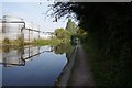
The canal runs past the Godiva Trading Estate.
The narrow canal was built to connect the city of Coventry with the Trent & Mersey Canal, some 38 miles distant, to exploit the Warwickshire coalfields. Construction of the canal took 20 years before it was complete in 1769. The canal between the basin in Coventry and Hawkesbury junction was made a conservation area in 2012.
Image: © Michael Dibb
Taken: 23 Sep 2021
0.09 miles
3

Pallets
Piles of pallets at the premises of logistics company DK Fulfilment alongside the Coventry Canal.
Image: © Ian Capper
Taken: 23 Sep 2021
0.10 miles
5
Old & New Foleshill
The Kurdistan Tandoori Naan takeaway on Foleshill Road has, on its side wall, a ghost sign for Spratt's Dog Food, the Spratt's name forming its distinctive terrier shape. Wikipedia tells us that Spratt's was founded in London around 1860 by the American James Spratt, and that the company pioneered hoarding or billboard advertisements in Britain and was one of the most heavily advertised brands in the early 20th century https://en.wikipedia.org/wiki/Spratt's .
Image: © A J Paxton
Taken: 7 Jul 2022
0.10 miles
6
![A stroll along the Coventry Canal to Hawkesbury Junction [23]](https://s0.geograph.org.uk/geophotos/07/12/19/7121940_db0b7a42_120x120.jpg)
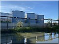
A stroll along the Coventry Canal to Hawkesbury Junction [23]
Seen across the canal, these tanks are part of the Godiva Trading Estate.
The narrow canal was built to connect the city of Coventry with the Trent & Mersey Canal, some 38 miles distant, to exploit the Warwickshire coalfields. Construction of the canal took 20 years before it was complete in 1769. The canal between the basin in Coventry and Hawkesbury junction was made a conservation area in 2012.
Image: © Michael Dibb
Taken: 23 Sep 2021
0.11 miles
8
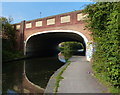
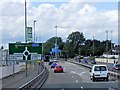
Bridge 6A: Phoenix Way
Carrying the A444 across the Coventry Canal.
Image: © Mat Fascione
Taken: 11 Sep 2014
0.11 miles
10
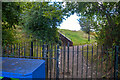
Coventry : Footpath
A footpath heads off the canal.
Image: © Lewis Clarke
Taken: 25 Sep 2021
0.12 miles