IMAGES TAKEN NEAR TO
Pridmore Road, COVENTRY, CV6 5PE
Introduction
This page details the photographs taken nearby to Pridmore Road, CV6 5PE by members of the Geograph project.
The Geograph project started in 2005 with the aim of publishing, organising and preserving representative images for every square kilometre of Great Britain, Ireland and the Isle of Man.

There are currently over 7.5m images from over14,400 individuals and you can help contribute to the project by visiting https://www.geograph.org.uk
Image Map
Images are licensed for reuse under creativecommons.org/licenses/by-sa/2.0
Notes
- Clicking on the map will re-center to the selected point.
- The higher the marker number, the further away the image location is from the centre of the postcode.
Image Listing (72 Images Found)
Images are licensed for reuse under creativecommons.org/licenses/by-sa/2.0
Image
Details
Distance
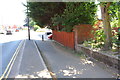
1
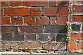
Benchmark on #43 Pridmore Road
Ordnance Survey cut mark benchmark levelled at 94.113m above Newlyn Datum
Image: © Roger Templeman
Taken: 10 Jul 2018
0.08 miles
2
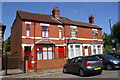
Pridmore Road houses
There is an OS benchmark Image on the side of the left hand house
Image: © Roger Templeman
Taken: 10 Jul 2018
0.08 miles
3
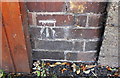
Benchmark on wall on west side of Lockhurst Lane
Ordnance Survey cut mark benchmark levelled at 95.921m above Newlyn Datum
Image: © Roger Templeman
Taken: 10 Jul 2018
0.09 miles
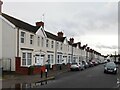
4
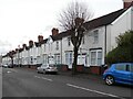
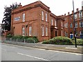
Former Coventry Corporation housing, Pridmore Road
These council houses were the first to be built in Coventry, in 1907. More followed soon after on neighbouring streets laid out by Narrow Lane (today Kingfield Road), and by 1912 over two hundred houses had been built by the city in this area. They were much needed at a time when the rapid industrial expansion of Coventry had led to an influx of workers and their families and housing was scarce. See David Fry & Albert Smith, The Coventry we have Lost: Forgotten Foleshill, Simanda Press, 2018, p27.
At the end of the 20th century the city's remaining housing stock was sold to a housing association. Many of the homes are now privately owned, but the uniform appearance of these suggests that they are still social housing. They are brick-built but have been covered with insulating cladding some time early in the 21st century, like these flats in Willenhall Image
Image: © A J Paxton
Taken: 14 Jan 2023
0.09 miles
5
Lockhurst Lane approaching the Stag and Pheasant pub
There is an OS benchmark Image on the end of the brick wall which is a boundary wall of the pub
Image: © Roger Templeman
Taken: 10 Jul 2018
0.09 miles
6
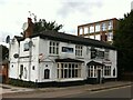
Stag & Pheasant, Lockhurst Lane, overlooked by former Courtaulds building, Foleshill
The Stag & Pheasant opened in 1830 and is a rare survivor of old Lockhurst Lane. Most of its neighbours were demolished in the course of the 20th century to make way for the Courtaulds textile works as it gradually expanded. See Fry, D & Smith, A, The Coventry we have lost: Forgotten Foleshill, Simanda Press, 2018, p26, which prints two photos of Lockhurst Lane in 1907 including the pub.
An English flag is displayed in the porch; inside are hung both English and Indian flags, and the lounge is given over to a simple Indian restaurant.
Image: © A J Paxton
Taken: 11 Sep 2021
0.09 miles
7
Former Coventry Corporation housing, Guild Road
These are some of the earliest council houses in Coventry, built by the city some time between 1907 and 1912. The very first row, on Pridmore Road, can be seen at the end of the street, on the right hand side of the photo, and also on this Geograph Image], which provides more information.
Image: © A J Paxton
Taken: 14 Jan 2023
0.09 miles
8
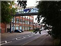
Former Courtaulds factory, Lockhurst Lane, Foleshill
The Lockhurst Lane 'bridge of sighs' connects two parts of Courtaulds textile works, which expanded along Lockhurst Lane in the years after 1918. The factory, which was known for making rayon and similar artificial fibres, closed in the 1990s and the surviving buildings have been put to a variety of commercial uses, with some converted to housing.
Image: © A J Paxton
Taken: 11 Sep 2021
0.11 miles
9
Coventry-HBT Communications
Looking from Pridmore Road.
Image: © Ian Rob
Taken: 20 Jul 2013
0.11 miles
10
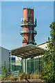
Former Courtaulds chimney
The base of a former chimney in the extensive Courtaulds textiles site, with part of Foleshill Enterprise Park, which now occupies part of the site, in the foreground.
Image: © Ian Capper
Taken: 23 Sep 2021
0.12 miles