IMAGES TAKEN NEAR TO
Eden Street, COVENTRY, CV6 5HH
Introduction
This page details the photographs taken nearby to Eden Street, CV6 5HH by members of the Geograph project.
The Geograph project started in 2005 with the aim of publishing, organising and preserving representative images for every square kilometre of Great Britain, Ireland and the Isle of Man.

There are currently over 7.5m images from over14,400 individuals and you can help contribute to the project by visiting https://www.geograph.org.uk
Image Map
Images are licensed for reuse under creativecommons.org/licenses/by-sa/2.0
Notes
- Clicking on the map will re-center to the selected point.
- The higher the marker number, the further away the image location is from the centre of the postcode.
Image Listing (66 Images Found)
Images are licensed for reuse under creativecommons.org/licenses/by-sa/2.0
Image
Details
Distance
1
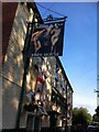
Adam & Eve public house, Eden Street
This district around Stoney Stanton Road, Coventry, is marked on the OS map as 'Paradise', though I have never heard anybody locally refer to it by that name. A ten-storey block of council flats called 'Paradise House' can also be found on Eden Street.
Image: © A J Paxton
Taken: 21 May 2014
0.02 miles
2
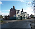
Coventry-Adam And Eve Public House
On Eden Street. Paradise, Foleshill.
Image: © Ian Rob
Taken: 24 Feb 2014
0.03 miles
3
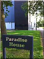
Paradise House sign and detail of tower block
“In my Father's house are many mansions: if it were not so, I would have told you. I go to prepare a place for you.” (John 14:2, King James Version). https://www.kingjamesbibleonline.org/John-14-2/ A block of Coventry council housing on Eden Street may not be what was intended here. This block of 58 flats in 10 storeys was constructed by Wimpey for Coventry County Borough Council between 1961 & 1962. https://www.towerblock.eca.ed.ac.uk/development/eden-street Nearby is the Adam & Eve pub.
Image: © A J Paxton
Taken: 21 May 2014
0.04 miles
4
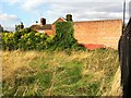
Overgrown plot, Stoney Stanton Road, Foleshill
This plot of land, fenced off from the road, is an unexpected patch of green in a very built-up area. On the far side can be seen the windowless wall of a workshop that is dated 1850 on the gable end that faces the road; a cottage stands next to it, and can be seen beyond and to the left of the workshop.
Image: © A J Paxton
Taken: 26 Aug 2021
0.06 miles
5
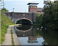
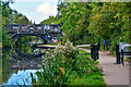
Bridge 6: Navigation Bridge
Crossing the Coventry Canal in Coventry.
Image: © Mat Fascione
Taken: 11 Sep 2014
0.07 miles
6
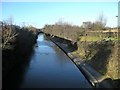
Coventry Canal
The low winter sun casts a shadow on the canal. Looking from Navigation Bridge.
Image: © Ian Rob
Taken: 9 Jan 2011
0.08 miles
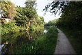
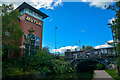
8
Coventry Canal Towpath
Approaching Navigation Bridge (Stoney Stanton Road).
Image: © Ian Rob
Taken: 9 Jan 2011
0.08 miles
9
Coventry : Coventry Canal
The Coventry Canal Company was formed in 1768. James Brindley was commissioned to build the canal, and work started on it in December that year.
Image: © Lewis Clarke
Taken: 25 Sep 2021
0.08 miles
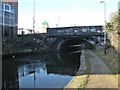
10
Coventry : Coventry Canal
The canal heads under Stoney Stanton Road.
Image: © Lewis Clarke
Taken: 25 Sep 2021
0.09 miles