IMAGES TAKEN NEAR TO
Hampton Road, COVENTRY, CV6 5GD
Introduction
This page details the photographs taken nearby to Hampton Road, CV6 5GD by members of the Geograph project.
The Geograph project started in 2005 with the aim of publishing, organising and preserving representative images for every square kilometre of Great Britain, Ireland and the Isle of Man.

There are currently over 7.5m images from over14,400 individuals and you can help contribute to the project by visiting https://www.geograph.org.uk
Image Map (Loading...)


Getting Data...Please wait
Leaflet Map data © OpenStreetMap
Images are licensed for reuse under creativecommons.org/licenses/by-sa/2.0
Notes
- Clicking on the map will re-center to the selected point.
- The higher the marker number, the further away the image location is from the centre of the postcode.
Image Listing (69 Images Found)
Images are licensed for reuse under creativecommons.org/licenses/by-sa/2.0
Image
Details
Distance
1
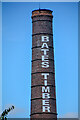
Coventry : Bates Timber Chimney
A chimney on the skyline.
Image: © Lewis Clarke
Taken: 25 Sep 2021
0.11 miles
2
![A stroll along the Coventry Canal to Hawkesbury Junction [18]](https://s1.geograph.org.uk/geophotos/07/12/11/7121153_cb669e1f_120x120.jpg)
A stroll along the Coventry Canal to Hawkesbury Junction [18]
An increasingly rare sight is this chimney, which was part of the former Webster's Brick works off Stoney Stanton Road.
The narrow canal was built to connect the city of Coventry with the Trent & Mersey Canal, some 38 miles distant, to exploit the Warwickshire coalfields. Construction of the canal took 20 years before it was complete in 1769. The canal between the basin in Coventry and Hawkesbury junction was made a conservation area in 2012.
Image: © Michael Dibb
Taken: 23 Sep 2021
0.11 miles
4
![A stroll along the Coventry Canal to Hawkesbury Junction [17]](https://s0.geograph.org.uk/geophotos/07/12/11/7121148_e20a2288_120x120.jpg)
A stroll along the Coventry Canal to Hawkesbury Junction [17]
A bucolic stretch of the canal just north of bridge 5b.
The narrow canal was built to connect the city of Coventry with the Trent & Mersey Canal, some 38 miles distant, to exploit the Warwickshire coalfields. Construction of the canal took 20 years before it was complete in 1769. The canal between the basin in Coventry and Hawkesbury junction was made a conservation area in 2012.
Image: © Michael Dibb
Taken: 23 Sep 2021
0.13 miles
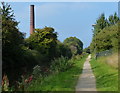
5

Coventry Canal, Stoke Heath
Ahead is Heath Crescent Bridge, a modern structure that appears unnumbered but stands between bridges 5 and 6.
Image: © Stephen McKay
Taken: 19 Oct 2008
0.13 miles
6
Paradise abandoned
The Growing Paradise community garden is looking very neglected. It is situated behind St. Barnabas Church of Masihi Sandesh at the crook of Oliver Street. This district of Coventry off Stoney Stanton Road is marked as Paradise on many maps.
Image: © A J Paxton
Taken: 26 Aug 2021
0.14 miles
7
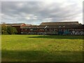
Red House Park, Foleshill, with factory buildings beyond
This is a view of part of Red House Park on Stoney Stanton Road, Coventry, looking southwards to the factory buildings located between the park, Oliver Street and Cromwell Street. This district of Coventry was dominated by the Coventry Ordnance Works, an armaments factory, which closed in 1925, although some of its buildings survive. The factory buildings in this photo are not marked on the OS Six Inch map of 1912; if they were part of the ordnance works they were built after that date, perhaps during the first world war. https://maps.nls.uk/geo/explore/side-by-side/#zoom=17&lat=52.42371&lon=-1.49354&layers=10&right=OSAPI
For more on Red House Park see Image For a detail of the graffiti on the wall, see Image For more on the Coventry Ordnance Works see Image
Image: © A J Paxton
Taken: 26 Aug 2021
0.14 miles
8
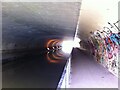
Coventry Canal passing under Waterman Road
Waterman Road links Red Lane with a large roundabout on the A444 Jimmy Hill Way, which was built in the 1990s, so this bridge-tunnel presumably dates from this time also. The new A444 was built on the route of a disused railway, and the OS one inch 7th series 1955-61 map shows a railway bridge here, carrying a siding to the ordnance works on Red Lane.
Image: © A J Paxton
Taken: 21 Mar 2019
0.14 miles
9
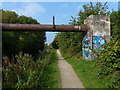
Pipebridge and towpath along the Coventry Canal
Image: © Mat Fascione
Taken: 11 Sep 2014
0.15 miles
10

Graffiti, Red House Park, Coventry
The graffiti has been painted on a factory wall on the south side of the park.
Image: © A J Paxton
Taken: 26 Aug 2021
0.15 miles