IMAGES TAKEN NEAR TO
Station Street East, COVENTRY, CV6 5FJ
Introduction
This page details the photographs taken nearby to Station Street East, CV6 5FJ by members of the Geograph project.
The Geograph project started in 2005 with the aim of publishing, organising and preserving representative images for every square kilometre of Great Britain, Ireland and the Isle of Man.

There are currently over 7.5m images from over14,400 individuals and you can help contribute to the project by visiting https://www.geograph.org.uk
Image Map
Images are licensed for reuse under creativecommons.org/licenses/by-sa/2.0
Notes
- Clicking on the map will re-center to the selected point.
- The higher the marker number, the further away the image location is from the centre of the postcode.
Image Listing (48 Images Found)
Images are licensed for reuse under creativecommons.org/licenses/by-sa/2.0
Image
Details
Distance
1
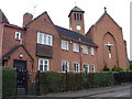
St Elizabeth's Roman Catholic Church, Foleshill, Coventry
View from St Elizabeth's Road, Foleshill. The junction with Eld Road is just out of shot to the right.
Image: © John Curran
Taken: 13 Feb 2010
0.08 miles
2
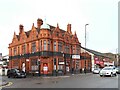
A Romanian barber at the General Wolfe
She has opened her business in a front room of the otherwise empty pub, having moved there from smaller premises further up Foleshill Road. Her striped Barber Shop sign can be seen above the windows of her salon.
The building is a prominent local landmark in Foleshill and dates from around 1900, though there has been a public house here since the 18th century. The General Wolfe pub closed in 2011; see Image
Image: © A J Paxton
Taken: 14 Jan 2023
0.09 miles
3
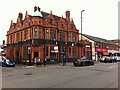
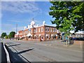
Former General Wolfe public house, Foleshill Road, Coventry
This building is a former public house standing at 551 Foleshill Road, at the corner with Station Road West. There has been a pub here since at least 1793. The present structure dates from around 1900 and exhibits an ornate Renaissance style executed in red brick and terracotta. It resembles Birmingham pubs more than Coventry ones, particularly those of James & Lister Lea, who may have designed it, though the architect is unknown. See the Heritage Gateway site, which quotes the City of Coventry Local List of Buildings and another City Council publication, A Survey of Public Art in Coventry, 1980, p.22 https://www.heritagegateway.org.uk/Gateway/Results_Single.aspx?uid=MCT317&resourceID=1029 .
General Wolfe defeated the French at the Battle of the Plains of Abraham outside Quebec City in 1759, which proved decisive in winning Canada for Britain. Both he and the French commander Montcalm died of wounds received in the fighting.
The pub was known as a rock and roll venue. It closed in 2011 and the building has since been used as a restaurant. See also the Historic Coventry site of Rob Orland https://www.historiccoventry.co.uk/cph/main/pub.php?pg=general_wolfe . At the time of writing and photographing the building was disused.
Image: © A J Paxton
Taken: 11 Sep 2021
0.09 miles
4
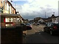
Foleshill Road looking south towards Station Street
Image: © A J Paxton
Taken: 31 Jul 2021
0.10 miles
5
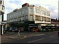
Opus Foods in former Co-op Emporium building, Foleshill Road, Coventry
The building stands at the corner of Foleshill Road and Holmsdale Road. It was built around 1931 to a design by W A Johnson, an in-house architect of the CWS (Co-operative Wholesale Society). Two storeys were intended originally, but it was built with three, which has evidently led to some cost-saving skimping on the details on the top floor https://www.heritagegateway.org.uk/Gateway/Results_Single.aspx?uid=MCT718&resourceID=1029 , but the parapet has attractive art deco flourishes nonetheless.
The building was empty for some years and until fairly recently still bore a Co-operative Emporium sign on its Foleshill Road facade. Opus Foods moved in around 2011. Heart of England Co-op maintained a supermarket nearby until 2006, when competition from the Tesco hypermarket at the Arena site proved too much; the Co-op store continues to trade as a funeral director.
Image: © A J Paxton
Taken: 31 Jul 2021
0.10 miles
6
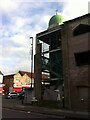
Unfinished mosque, corner of Foleshill Road and Blackwell Road, Coventry
Construction of this building seems to have halted. Known as the Edgwick Family & Learning Centre, it was given planning permission in 2005 and work began on decontaminating the site, which had once been occupied by a battery factory. https://www.coventrytelegraph.net/news/coventry-news/six-months-left-finish-building-3023372 Building progress has been very slow, and when this photo was taken in July 2021 the work was far from complete.
Image: © A J Paxton
Taken: 31 Jul 2021
0.11 miles
7
The unfinished mosque is still unfinished
For more information see Image] and this article in the Coventry Telegraph https://www.coventrytelegraph.net/news/coventry-news/six-months-left-finish-building-3023372 , which dates from 2012 and states that the planning permission required completion of the building by the end of that year. This photo was taken over ten years later. The building fronts on to Foleshill Road; the side elevation on Blackwell Road is shown here.
Image: © A J Paxton
Taken: 16 Mar 2023
0.12 miles
8
Foleshill, temple
Sri Guru Ravidass Temple, on Foleshill Road: http://www.ravidassji.org.uk/about.htm
Image: © Mike Faherty
Taken: 8 Jun 2014
0.13 miles
9

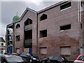
Detail of Broad Street Meeting Hall, Foleshill, Coventry
This is the entrance to the old hall, which no longer exists, through the adjoining Victorian house and shopfront, which still stand next to the new meeting hall, which opened in 2020.
Image: © A J Paxton
Taken: 16 Aug 2021
0.14 miles
10

Shri Guru Ravidass Temple, Coventry, seen from the Foleshill Road
This is a temple of the Ravidassia community and is dedicated to Shri Guru Ravidass Ji Maharaj, a holy man and social reformer, who challenged the caste divisions of Indian society and taught a religious path available to all; see Image] . The temple opened in a converted industrial building in 1996, as explained on its website here http://www.ravidassji.org.uk/about.htm . The adjoining building, to the left of this photo, is still used by an aerospace engineering company.
Image: © A J Paxton
Taken: 11 Sep 2021
0.14 miles