IMAGES TAKEN NEAR TO
Smith Street, COVENTRY, CV6 5DX
Introduction
This page details the photographs taken nearby to Smith Street, CV6 5DX by members of the Geograph project.
The Geograph project started in 2005 with the aim of publishing, organising and preserving representative images for every square kilometre of Great Britain, Ireland and the Isle of Man.

There are currently over 7.5m images from over14,400 individuals and you can help contribute to the project by visiting https://www.geograph.org.uk
Image Map
Images are licensed for reuse under creativecommons.org/licenses/by-sa/2.0
Notes
- Clicking on the map will re-center to the selected point.
- The higher the marker number, the further away the image location is from the centre of the postcode.
Image Listing (132 Images Found)
Images are licensed for reuse under creativecommons.org/licenses/by-sa/2.0
Image
Details
Distance
1
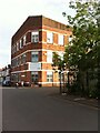
Mosque on Smith Street, Coventry
Mosque in a converted factory building at the corner of Smith Street and Midland Road, part of a small area of streets between Red Lane, the former ordnance factory and the canal. It may have been built as part of the ordnance works, since it is marked as part of the factory site on this plan: https://www.gracesguide.co.uk/File:ImV103-p547.jpg The mosque is called the Shah Jalal Jame Masjid and serves the local Bangladeshi community.
Image: © A J Paxton
Taken: 14 Jun 2021
0.02 miles
2
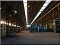
Inside the Ordnance Works
Difficult to photograph. Trying to give an idea of the size of the building. Now used for storing Jaguar car parts
Image: © Kevin Croucher
Taken: 13 Jun 2005
0.05 miles
3
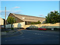
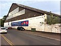
Southern End of Red Lane Ordnance Works
The northern end can be seen in image Image
The Coventry Ordanace works was established here in 1902. After World War One, the factory passed to the English Electric Company Limited. It is currently used to store automotive parts.
Image: © Keith Williams
Taken: 13 May 2015
0.10 miles
4
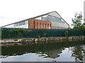
Royal Ordnance factory building
This was the massive Naval Gun Shop. It measures 283m long and 60m wide and when it was built in 1906 it was the largest industrial building in Europe.
It is not listed but is included in the Coventry Canal Conservation Area. This describes it as one of Coventry's last surviving iconic industrial buildings and it is likely to be the only building of its kind in Britain. It is therefore of high historic and architectural interest. Its future must however remain problematical. There are some fascinating pictures of the interior in this link https://www.coventrytelegraph.net/lifestyle/nostalgia/gallery/coventrys-munitions-industry-7419447
Image: © Alan Murray-Rust
Taken: 23 Sep 2021
0.10 miles
5
Red Lane Ordnance Works
An enormous building. Amongst other things, First World War naval guns were made here.
Image: © Kevin Croucher
Taken: 13 Jun 2005
0.10 miles
6
Former ordnance works, Red Lane. Coventry
This factory shed was part of Coventry Ordnance Works, a large site between Stoney Stanton Road, Red Lane and the canal where armaments were made between 1900 and 1925. https://www.gracesguide.co.uk/Coventry_Ordnance_Co https://www.gracesguide.co.uk/Coventry_Ordnance_Works A plan of the site marks this building as containing the large machine shop, large erecting shop and large gun bay. https://www.gracesguide.co.uk/File:ImV103-p547.jpg The works closed in 1925, but, while the part of the factory on Ordnance Road, off Stoney Stanton Road, has long since been demolished, this unit has survived. It was in use as a warehouse for many years but now appears to be empty.
Image: © A J Paxton
Taken: 14 Jun 2021
0.11 miles
7

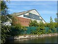
Coventry : Coventry Canal
The Coventry Canal is a navigable narrow canal in the Midlands of England.
Image: © Lewis Clarke
Taken: 25 Sep 2021
0.11 miles
9
![A stroll along the Coventry Canal to Hawkesbury Junction [9]](https://s1.geograph.org.uk/geophotos/07/12/11/7121129_c7726023_120x120.jpg)
A stroll along the Coventry Canal to Hawkesbury Junction [9]
Seen across the canal is the former Naval Gun Shop, part of the Royal Ordnance. When built in 1906 it was the largest industrial building in Europe at 930 feet (283 metres) long and 195 feet (60 metres) wide. During the First World War tanks and aeroplanes were built here.
The narrow canal was built to connect the city of Coventry with the Trent & Mersey Canal, some 38 miles distant, to exploit the Warwickshire coalfields. Construction of the canal took 20 years before it was complete in 1769. The canal between the basin in Coventry and Hawkesbury junction was made a conservation area in 2012.
Image: © Michael Dibb
Taken: 23 Sep 2021
0.11 miles
10
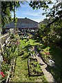
![A stroll along the Coventry Canal to Hawkesbury Junction [7]](https://s3.geograph.org.uk/geophotos/07/12/11/7121123_cf2fa9ff_120x120.jpg)
A stroll along the Coventry Canal to Hawkesbury Junction [7]
A rear garden full of kitsch belonging to a house in The Chantries.
The narrow canal was built to connect the city of Coventry with the Trent & Mersey Canal, some 38 miles distant, to exploit the Warwickshire coalfields. Construction of the canal took 20 years before it was complete in 1769. The canal between the basin in Coventry and Hawkesbury junction was made a conservation area in 2012.
Image: © Michael Dibb
Taken: 23 Sep 2021
0.12 miles