IMAGES TAKEN NEAR TO
West Avenue, COVENTRY, CV6 4QE
Introduction
This page details the photographs taken nearby to West Avenue, CV6 4QE by members of the Geograph project.
The Geograph project started in 2005 with the aim of publishing, organising and preserving representative images for every square kilometre of Great Britain, Ireland and the Isle of Man.

There are currently over 7.5m images from over14,400 individuals and you can help contribute to the project by visiting https://www.geograph.org.uk
Image Map
Images are licensed for reuse under creativecommons.org/licenses/by-sa/2.0
Notes
- Clicking on the map will re-center to the selected point.
- The higher the marker number, the further away the image location is from the centre of the postcode.
Image Listing (14 Images Found)
Images are licensed for reuse under creativecommons.org/licenses/by-sa/2.0
Image
Details
Distance
1

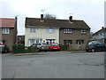
Bus in turning circle, Prologis Park, Keresley
Travel Coventry 4695, a Volvo B7TL/Wright Eclipse Gemini, lays over in the turning circle at the north end of Prologis Park before working a 13 to Willenhall via Radford, Coventry city centre, and Binley Road. Prologis Park was built on the site of Coventry Colliery; the housing visible on the right, on Exhall Road in Keresley Village, was built for the miners.
Image: © Richard Vince
Taken: 28 Sep 2007
0.06 miles
2
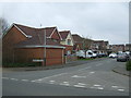
Mercers Meadow, Keresley Newlands
Housing off Exhall Road.
Image: © JThomas
Taken: 11 Mar 2017
0.13 miles
3

New offices at the site of Coventry Colliery
Some of the new office blocks, and in the distance, warehouse units on the site of the former Coventry Colliery. The colliery closed in 1993.
Image: © David Stowell
Taken: 27 Aug 2006
0.15 miles
4
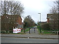
Dual use path, Keresley Newlands
Looking south from Exhall Road.
Image: © JThomas
Taken: 11 Mar 2017
0.19 miles
6
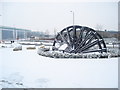
Coventry Colliery Monument
Monument erected in 2008 to the workers at the former Coventry Colliery and smokeless fuel plant. The colliery site is now occupied by the warehouses of Prologis Park, visible in the background.
Image: © A J Paxton
Taken: 5 Feb 2009
0.22 miles
7
Farmland, Keresley Newlands
North of Exhall Road.
Image: © JThomas
Taken: 11 Mar 2017
0.23 miles
8

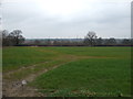
Meadow at Prologis Country Park
Morning view, looking towards Keresley Village, the former mining village. This large meadow is at the western end of the country park that adjoins, and belongs to, the Prologis Park business park development on the site of the Coventry Colliery.
Image: © A J Paxton
Taken: 15 Jun 2021
0.23 miles
9
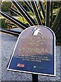
Plaque on Coventry Colliery monument, Prologis Park, Keresley
The plaque is placed next to a monument made from one of the pit wheels from the mine's winding gear, which can be seen here Image It is dedicated to the worksers at the colliery and the adjoining Homefires smokeless fuel plant. The dates quoted seem to be in error, however. The mine closed in 1991, was reopened by a private company and finally closed in 1996; see here https://www.ourwarwickshire.org.uk/content/article/coventry-colliery-2 .
Image: © A J Paxton
Taken: 7 Sep 2021
0.23 miles
10
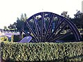
Monument to the workers at the Coventry Colliery & Homefires Plant, Prologis Park, Keresley
This monument was erected in 2008 to remember the workers at the Coventry Colliery and the Homefires smokeless fuel plant. It is located on the edge of Prologis Park, a business park that occupies the site of the coal mine. The monument is made out of a pit wheel, one of four that were in use at the mine at the time of its closure in 1991. The wheel formed part of the winding gear that pulled cages from the mine to the surface and lowered them again, carrying coal, equipment and the miners themselves. http://www.bbc.co.uk/history/british/victorians/launch_ani_winding_gear.shtml . The shafts of the Coventry Colliery extended 660m below ground level when they were sunk in 1917 https://en.wikipedia.org/wiki/Coventry_Colliery . For a photo of the monument taken in the year it was erected see here Image
Image: © A J Paxton
Taken: 7 Sep 2021
0.23 miles