IMAGES TAKEN NEAR TO
Dymond Road, COVENTRY, CV6 4JZ
Introduction
This page details the photographs taken nearby to Dymond Road, CV6 4JZ by members of the Geograph project.
The Geograph project started in 2005 with the aim of publishing, organising and preserving representative images for every square kilometre of Great Britain, Ireland and the Isle of Man.

There are currently over 7.5m images from over14,400 individuals and you can help contribute to the project by visiting https://www.geograph.org.uk
Image Map (Loading...)


Getting Data...Please wait
Leaflet Map data © OpenStreetMap
Images are licensed for reuse under creativecommons.org/licenses/by-sa/2.0
Notes
- Clicking on the map will re-center to the selected point.
- The higher the marker number, the further away the image location is from the centre of the postcode.
Image Listing (57 Images Found)
Images are licensed for reuse under creativecommons.org/licenses/by-sa/2.0
Image
Details
Distance
1
Foleshill Gas Tower as seen from Dymond Road
The tower's final day of dominating the landscape before demolition early the next morning.
Image: © Niki Walton
Taken: 21 Sep 2002
0.04 miles
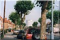
2
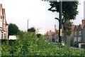
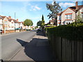
Junction of Dymond Road and Butlin Road
Part of a small estate of council housing built in 1936, the houses in the area are now a mix of owner-occupier, private rental, and housing association-owned homes.
Image: © Niki Walton
Taken: 22 Apr 2017
0.05 miles
3
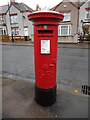
Postbox, Briscoe Road
Located at the point where Briscoe Road and Dymond Road meet.
Image: © Niki Walton
Taken: 14 Nov 2015
0.08 miles
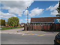
4
Former library, Briscoe Road
Recently converted for use as daycare for preschool-age children, this building served as the Holbrooks branch of Coventry City Libraries until 2003, when it was succeeded by the much larger Arena Park library at the nearby Arena Shopping Centre. For the last few decades of its life the left half of the building (its doors visible through the railings) was the entire open library with the right half of the building being used for storage and administration, but until the early 1970s the left half was the general library and the right half was the children's library.
Image: © Niki Walton
Taken: 14 Nov 2015
0.09 miles
5
Foleshill Gas Tower as seen from Hen Lane
As seen on its final day before demolition.
Image: © Niki Walton
Taken: 21 Sep 2002
0.10 miles
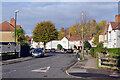
6
John Shelton Drive, Holbrooks
Looking past the childcare centre (formerly Holbrooks library) to John Shelton Drive and its houses, built around the turn of the 21st century on the site of the previous community centre and John Shelton Primary School (both rebuilt on a smaller scale on the same site).
Image: © Niki Walton
Taken: 22 Apr 2017
0.10 miles
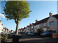
7
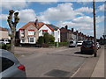
Briscoe Road, Holbrooks
Briscoe Road, with its mixture of semi-detached and terraced houses, bends away from Hen Lane in the Coventry suburbs.
Image: © Stephen McKay
Taken: 18 Nov 2022
0.11 miles
8
Butlin Road
Originally built as a small council housing estate in 1936, now a mix of housing association, owner-occupied, and privately rented houses.
Image: © Niki Walton
Taken: 4 May 2017
0.11 miles
9
Briscoe Road
Viewed from the junction with Butlin Road. The estate was built in 1936.
Image: © Niki Walton
Taken: 4 May 2017
0.11 miles
10
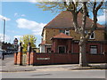
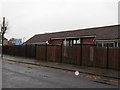
Doctor's surgery
A long-established GP surgery on the corner of Wheelwright Lane and Roland Avenue.
Image: © Niki Walton
Taken: 22 Apr 2017
0.12 miles