IMAGES TAKEN NEAR TO
Wheelwright Lane, COVENTRY, CV6 4HH
Introduction
This page details the photographs taken nearby to Wheelwright Lane, CV6 4HH by members of the Geograph project.
The Geograph project started in 2005 with the aim of publishing, organising and preserving representative images for every square kilometre of Great Britain, Ireland and the Isle of Man.

There are currently over 7.5m images from over14,400 individuals and you can help contribute to the project by visiting https://www.geograph.org.uk
Image Map
Images are licensed for reuse under creativecommons.org/licenses/by-sa/2.0
Notes
- Clicking on the map will re-center to the selected point.
- The higher the marker number, the further away the image location is from the centre of the postcode.
Image Listing (59 Images Found)
Images are licensed for reuse under creativecommons.org/licenses/by-sa/2.0
Image
Details
Distance
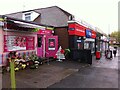
1
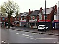
Shops on Wheelwright Lane, Holbrooks, Coventry, across from junction with Nunts Lane
On a chilly wet Friday morning in May.
Image: © A J Paxton
Taken: 21 May 2021
0.01 miles
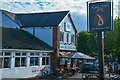
2
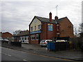
The Hub, Holbrooks
A rather oddly architectured pub on Wheelwright Lane, only just inside the city of Coventry.
Image: © Richard Vince
Taken: 2 Apr 2016
0.02 miles
3
Wheelwright Lane bus terminus, Holbrooks
Located in the V between Nunts Lane and Wheelwright Lane (foreground), this little cut through enables buses on route 13, which approach via Nunts Lane, to return whence they came. Despite being at the north end of Holbrooks, buses terminating here shown "Whitmore Park", just about the only remaining one of a few examples of buses in Coventry showing a destination that is more about how they get to where they're going than where they actually end up.
Image: © Richard Vince
Taken: 2 Apr 2016
0.02 miles
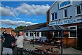
4
The Hub, Wheelwright Lane
A long-established pub, now offering a curry menu in addition to match-day parking for the nearby Ricoh Arena and Sky Sports.
Image: © Niki Walton
Taken: 22 Apr 2017
0.02 miles
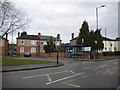
5
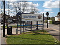
City of Peace and Reconciliation
Now that the number 13 bus has departed this is a quiet scene, showing the sign welcoming people travelling south from Warwickshire to Coventry, the city of peace and reconciliation.
Image: © Niki Walton
Taken: 22 Apr 2017
0.02 miles
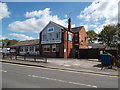
6
Coventry : The Hub Pub
The premises opened as an off license and was called the 'Ivy Cottage'.
It is said to have become a pub around 1963 by the demand of the pit villagers and the name changed to the 'Hub' because of its location.
Image: © Lewis Clarke
Taken: 25 Sep 2021
0.02 miles
7
Coventry : The Hub Pub
The premises opened as an off licence and was called the 'Ivy Cottage'.
It is said to have become a pub around 1963 by the demand of the pit villagers and the name changed to the 'Hub' because of its location.
When you walk around with an SLR camera you occasionally get people who like to pose for a photograph, or in this case, even ask for their photo to be taken.
Image: © Lewis Clarke
Taken: 25 Sep 2021
0.02 miles
8
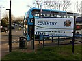
Terminus of No. 13 bus, Holbrooks
At the junction of Nunts Lane (where the bus is parked) and Wheelwright Lane, curving off to the left in the direction of Coventry. The sign indicates the city's northern boundary.
Image: © A J Paxton
Taken: 4 Apr 2021
0.03 miles
9
Row of shops, Wheelwright Lane, Holbrooks
The junction with Nunts Lane can be seen just beyond the row. These appear from the front to be single-storey, lock-up shops, though the dormer window on the side of the One Stop shop suggests housing above and behind.
Image: © A J Paxton
Taken: 21 May 2021
0.03 miles
10
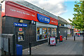
Coventry : One Stop Community Stores
A One Stop shop on Wheelwright Lane.
Image: © Lewis Clarke
Taken: 25 Sep 2021
0.03 miles