IMAGES TAKEN NEAR TO
Sidbury Road, COVENTRY, CV6 3LE
Introduction
This page details the photographs taken nearby to Sidbury Road, CV6 3LE by members of the Geograph project.
The Geograph project started in 2005 with the aim of publishing, organising and preserving representative images for every square kilometre of Great Britain, Ireland and the Isle of Man.

There are currently over 7.5m images from over14,400 individuals and you can help contribute to the project by visiting https://www.geograph.org.uk
Image Map (Loading...)


Getting Data...Please wait
Leaflet Map data © OpenStreetMap
Images are licensed for reuse under creativecommons.org/licenses/by-sa/2.0
Notes
- Clicking on the map will re-center to the selected point.
- The higher the marker number, the further away the image location is from the centre of the postcode.
Image Listing (54 Images Found)
Images are licensed for reuse under creativecommons.org/licenses/by-sa/2.0
Image
Details
Distance
1
Radford fire station
Radford old fire station, Chetton Avenue, Daimler Green, Radford, Coventry, West Midlands. Now used as a children's nursery
Image: © Kevin Hale
Taken: 25 Jan 2009
0.09 miles
4
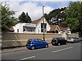
Off licence and houses at north end of Sandy Lane
Image: © Roger Templeman
Taken: 10 Jul 2018
0.13 miles
5
Coventry-Shree Shree Radha Krishna Cultural Centre
On Kingfield Road.
Image: © Ian Rob
Taken: 20 Jul 2013
0.17 miles
6

Cheveral Avenue
These are terraced houses at the southern end of Cheveral Avenue close to its junction with Middlemarch Rd.
Image: © Nigel Mykura
Taken: 13 Aug 2010
0.17 miles
7
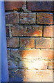
Benchmark on wall of former building, Kingfield Road
Ordnance Survey cut mark benchmark levelled at 97.679m above Newlyn Datum
Image: © Roger Templeman
Taken: 10 Jul 2018
0.18 miles
8
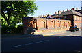
Brick wall at Kingfield Road / Kirby Close junction
The brick wall is all that remains of a demolished building. There is an OS benchmark Image about 5ft from the left hand end of the wall immediately right of a road sign pole
Image: © Roger Templeman
Taken: 10 Jul 2018
0.18 miles
9
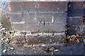
Benchmark on wall junction on west side of Widdrington Road
Ordnance Survey cut mark benchmark levelled at 97.972m above Newlyn Datum
Image: © Roger Templeman
Taken: 10 Jul 2018
0.18 miles
10
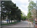
Scots pines on Cash's Lane
Old 1:2500 Ordnance Survey maps from 1937 and 1951 show allotment gardens located in the area behind the pines. The sign says it is now Cash's Business Centre.
Image: © E Gammie
Taken: 12 May 2012
0.18 miles