IMAGES TAKEN NEAR TO
Lowe Road, COVENTRY, CV6 2FZ
Introduction
This page details the photographs taken nearby to Lowe Road, CV6 2FZ by members of the Geograph project.
The Geograph project started in 2005 with the aim of publishing, organising and preserving representative images for every square kilometre of Great Britain, Ireland and the Isle of Man.

There are currently over 7.5m images from over14,400 individuals and you can help contribute to the project by visiting https://www.geograph.org.uk
Image Map
Images are licensed for reuse under creativecommons.org/licenses/by-sa/2.0
Notes
- Clicking on the map will re-center to the selected point.
- The higher the marker number, the further away the image location is from the centre of the postcode.
Image Listing (23 Images Found)
Images are licensed for reuse under creativecommons.org/licenses/by-sa/2.0
Image
Details
Distance

7
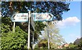
Old direction signs on Bennetts Road South, Keresley Green
The direction signs with blue edges were introduced for local destinations in 1964 and narrowed the bands in the late 60s before being changed to black as people apparently didn't understand what they meant. They echoed the pre-Worboys colour signs they replaced.
Image: © David Howard
Taken: 21 May 2023
0.15 miles
10
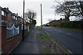
Bus stop and shelter on Bennetts Road South, Keresley
Looking north.
Image: © JThomas
Taken: 4 Mar 2017
0.18 miles