IMAGES TAKEN NEAR TO
The Scotchill, COVENTRY, CV6 2ER
Introduction
This page details the photographs taken nearby to The Scotchill, CV6 2ER by members of the Geograph project.
The Geograph project started in 2005 with the aim of publishing, organising and preserving representative images for every square kilometre of Great Britain, Ireland and the Isle of Man.

There are currently over 7.5m images from over14,400 individuals and you can help contribute to the project by visiting https://www.geograph.org.uk
Image Map (Loading...)


Getting Data...Please wait
Leaflet Map data © OpenStreetMap
Images are licensed for reuse under creativecommons.org/licenses/by-sa/2.0
Notes
- Clicking on the map will re-center to the selected point.
- The higher the marker number, the further away the image location is from the centre of the postcode.
Image Listing (48 Images Found)
Images are licensed for reuse under creativecommons.org/licenses/by-sa/2.0
Image
Details
Distance
1
The Scotchill, seen from Keresley Green road junction
The Scotchill leads to Burnaby Road, and both are lined with suburban housing from the 1920s-1930s.
Image: © A J Paxton
Taken: 8 Sep 2021
0.05 miles
3

Keresley Supermarket
Convenience store at the corner of Keresley Green Road and The Scotchill.
Image: © Mike Faherty
Taken: 7 Jun 2014
0.06 miles
4
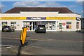
SKM Convenience Store on Keresley Green Road
Previously Keresley Supermarket a few years ago.
Image: © David Howard
Taken: 21 May 2023
0.07 miles
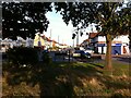
5
Road junction viewed from Keresley Green
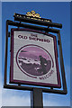
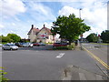
This view from Keresley Green overlooks the junction of, from left to right, Keresley Green Road, the Scotchill, Keresley Road (the dual carriageway visible at the right hand side of the photo) and Tamworth Road (off to the right and not visible here). The Old Shepherd, a 1930s roadside pub in 'black-and-white' timber-framed style, can be seen in the middle right, just to the left of the roundabout with the keep left signs.
Image: © A J Paxton
Taken: 8 Sep 2021
0.07 miles
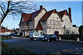
7
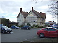
The Old Shepherd public house
On Keresley Road (B4098), Coventry.
Image: © JThomas
Taken: 4 Mar 2017
0.08 miles
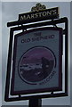
8
Keresley, The Old Shepherd
1930s-looking Marston's roadhouse on Keresley Road; central bar with eating and drinking areas on three sides; TV, games machines, garden, play area. Cask ales on offer at my visit: Banks's Bitter, Marston's EPA, Wychwood Hobgoblin.
Image: © Mike Faherty
Taken: 7 Jun 2014
0.08 miles
9
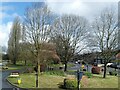
Keresley Green, Coventry
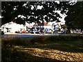
Keresley Road forks here; Tamworth Road continues off to the left, by the temporary a sign on a yellow wheeled base, while Keresley Green Road can be seen to the right, with the triangular green between the two. There are some attractive trees here: to the left, extending to the top of the picture, is a Turkey oak that has a fine display of foliage in autumn.
Image: © A J Paxton
Taken: 29 Mar 2024
0.08 miles