IMAGES TAKEN NEAR TO
Mapleton Road, COVENTRY, CV6 2AY
Introduction
This page details the photographs taken nearby to Mapleton Road, CV6 2AY by members of the Geograph project.
The Geograph project started in 2005 with the aim of publishing, organising and preserving representative images for every square kilometre of Great Britain, Ireland and the Isle of Man.

There are currently over 7.5m images from over14,400 individuals and you can help contribute to the project by visiting https://www.geograph.org.uk
Image Map (Loading...)


Getting Data...Please wait
Leaflet Map data © OpenStreetMap
Images are licensed for reuse under creativecommons.org/licenses/by-sa/2.0
Notes
- Clicking on the map will re-center to the selected point.
- The higher the marker number, the further away the image location is from the centre of the postcode.
Image Listing (4 Images Found)
Images are licensed for reuse under creativecommons.org/licenses/by-sa/2.0
Image
Details
Distance
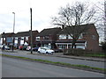
2
Peter Rabbit
On Brownshill Green Road, Coundon
Image: © David Howard
Taken: 21 May 2023
0.05 miles
3
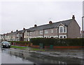
Brownshill Green Rd
A wet grey day in western Coventry. Not the best time to see these rather grey examples of terraced social housing. The uniform grey pebble-dashing seems to monotonise the appearance
Image: © Nigel Mykura
Taken: 4 Mar 2012
0.10 miles