IMAGES TAKEN NEAR TO
Beech Road, COVENTRY, CV6 1NZ
Introduction
This page details the photographs taken nearby to Beech Road, CV6 1NZ by members of the Geograph project.
The Geograph project started in 2005 with the aim of publishing, organising and preserving representative images for every square kilometre of Great Britain, Ireland and the Isle of Man.

There are currently over 7.5m images from over14,400 individuals and you can help contribute to the project by visiting https://www.geograph.org.uk
Image Map
Images are licensed for reuse under creativecommons.org/licenses/by-sa/2.0
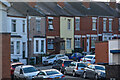
Notes
- Clicking on the map will re-center to the selected point.
- The higher the marker number, the further away the image location is from the centre of the postcode.
Image Listing (64 Images Found)
Images are licensed for reuse under creativecommons.org/licenses/by-sa/2.0
Image
Details
Distance
1
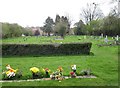
Churchyard of St Nicholas, Radford
Somewhere down on the left is the site of the original Victorian parish church. In November 1940 it was completely destroyed in an air raid. Four people sheltering in the crypt were killed. The present church, completed in 1955, is behind the camera Image
Image: © Robin Stott
Taken: 16 Apr 2010
0.05 miles
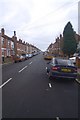
2
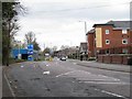
Radford Road
Arc car wash on the left, new Otterbrook Court housing on the right, Aldi supermarket just behind it.
Image: © Robin Stott
Taken: 16 Apr 2010
0.06 miles
3
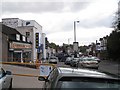
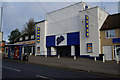
Radford Leather, Bingo hall and shops
Looking southeast down Radford Road towards the city. That bingo hall has to be a former cinema. The ramp with the orange railings on the left leads to a footpath to Cheveral Avenue and to Spring House, the blackened premises of S.Porretta & Sons Ltd, coal merchants Image
Image: © Robin Stott
Taken: 16 Apr 2010
0.07 miles
4
Coventry : Poole Road
Poole Road heads off from Lawrence Saunders Road.
Image: © Lewis Clarke
Taken: 25 Sep 2021
0.07 miles
5
Coventry : Dugdale Road
Looking across Radford Road and towards Dugdale Road.
Image: © Lewis Clarke
Taken: 25 Sep 2021
0.08 miles
6
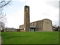
St Nicholas Church, Radford
The church was completed to "a highly original design" and consecrated in September 1955. Although somewhat altered and extended, the church has been proposed for Grade II listing by the Twentieth Century Society http://www.c20society.org.uk/ The church replaced a modest Victorian parish church, sited to the southwest, that was destroyed in an air raid in November 1940 with the loss of four lives.
Image: © Robin Stott
Taken: 16 Apr 2010
0.08 miles
7
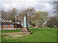
Radford War Memorial
It commemorates those from Radford who fought in the First World War and was given to the village in 1919 by Vernon Pugh. It was originally sited on the corner of Radford Common, at the junction with Engleton Road, seen in Image and in the distance, right http://www.geograph.org.uk/photo/583290 . It was moved in the 1980s at the suggestion of the British Legion, who were concerned about the damage it was incurring, and the sometimes muddy nature of the site. Thirty years on, between St Nicholas Church and the Radford Road, the memorial is no less prone to damage.
Image: © Robin Stott
Taken: 16 Apr 2010
0.08 miles
8
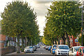
Wyley Road, Radford
A photo of Wyley Road in Radford, Coventry...a popular student street.
Image: © Richard Harrison
Taken: 15 Jan 2006
0.09 miles
10
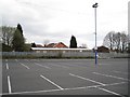
Gala Bingo car park, Radford
On a Friday morning Image The blue sign on the concrete hut says '8th Scout Headquarters'. The brick building behind it is missing part of its roof.
Image: © Robin Stott
Taken: 16 Apr 2010
0.10 miles