IMAGES TAKEN NEAR TO
Moseley Avenue, COVENTRY, CV6 1HS
Introduction
This page details the photographs taken nearby to Moseley Avenue, CV6 1HS by members of the Geograph project.
The Geograph project started in 2005 with the aim of publishing, organising and preserving representative images for every square kilometre of Great Britain, Ireland and the Isle of Man.

There are currently over 7.5m images from over14,400 individuals and you can help contribute to the project by visiting https://www.geograph.org.uk
Image Map
Images are licensed for reuse under creativecommons.org/licenses/by-sa/2.0
Notes
- Clicking on the map will re-center to the selected point.
- The higher the marker number, the further away the image location is from the centre of the postcode.
Image Listing (52 Images Found)
Images are licensed for reuse under creativecommons.org/licenses/by-sa/2.0
Image
Details
Distance
2
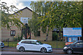
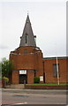
Coventry : Lawrence Saunders Road Baptist Church
In 1926 the Coventry Council of Baptist Churches decided to found a church in the Radford area of Coventry. In July 1931 builder W H Jones commenced construction on 2500sq yards of land purchsed from Coventry Corporation, and the total building cost was £1,263 6s 9d.
Originally called Radford Baptist Church, its name was changed to Lawrence Saunders Baptist Church, as visiting speakers often had problems finding the church which is right on the edge of the Radford/Coundon area.
Image: © Lewis Clarke
Taken: 25 Sep 2021
0.08 miles
3
Lawrence Saunders Road Baptist Church
Image: © Keith Williams
Taken: 12 Jun 2008
0.09 miles
5
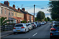
Coventry : Tomson Avenue
Looking along Tomson Avenue.
Image: © Lewis Clarke
Taken: 25 Sep 2021
0.12 miles
6
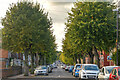
Coventry : Poole Road
Poole Road heads off from Lawrence Saunders Road.
Image: © Lewis Clarke
Taken: 25 Sep 2021
0.13 miles
7
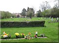
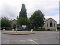
Churchyard of St Nicholas, Radford
Somewhere down on the left is the site of the original Victorian parish church. In November 1940 it was completely destroyed in an air raid. Four people sheltering in the crypt were killed. The present church, completed in 1955, is behind the camera Image
Image: © Robin Stott
Taken: 16 Apr 2010
0.14 miles
8
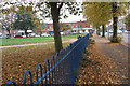
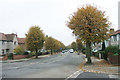
Crampers Field and Moseley Avenue, Radford, Coventry
Image: © Niki Walton
Taken: 12 Oct 2007
0.16 miles

10
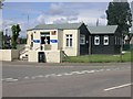
St George's Church, Barkers Butts Lane
Image: © Roger Templeman
Taken: 30 Apr 2018
0.16 miles