IMAGES TAKEN NEAR TO
Denbigh Road, COVENTRY, CV6 1GA
Introduction
This page details the photographs taken nearby to Denbigh Road, CV6 1GA by members of the Geograph project.
The Geograph project started in 2005 with the aim of publishing, organising and preserving representative images for every square kilometre of Great Britain, Ireland and the Isle of Man.

There are currently over 7.5m images from over14,400 individuals and you can help contribute to the project by visiting https://www.geograph.org.uk
Image Map
Images are licensed for reuse under creativecommons.org/licenses/by-sa/2.0
Notes
- Clicking on the map will re-center to the selected point.
- The higher the marker number, the further away the image location is from the centre of the postcode.
Image Listing (11 Images Found)
Images are licensed for reuse under creativecommons.org/licenses/by-sa/2.0
Image
Details
Distance
2
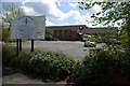
Catholic Church of Christ the King and Our Lady of Lourdes
Image: © Keith Williams
Taken: 23 Apr 2008
0.17 miles
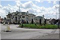
3
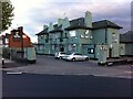
The Lion's Inn, formerly the Cedars, Coundon, Coventry
The pub faces onto Barker's Butts Lane, by a roundabout, with Cedars Avenue leading off to the right of the picture. Another of Coventry's suburban interwar roadside pubs, this one is distinguished architecturally by its pair of Dutch gables offsetting a roof of green pantiles. Since its change of name in 2018 the pubs outside walls have been painted a pastel green to match the tiles. https://www.historiccoventry.co.uk/cph/main/pub.php?pg=lions_inn_barker_butts_la
Image: © A J Paxton
Taken: 9 Jun 2021
0.20 miles
4
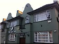
Pub restaurant at top of Barker's Butts Lane, Coundon
Formerly the Cedars, this 1920s roadside pub, with its distinctive Dutch gables and green-glazed roof tiles, has been back in business again since 2018 as The Lion's Inn, the stucco painted a drab green to match the roof. https://www.historiccoventry.co.uk/cph/main/pub.php?pg=cedars
Image: © A J Paxton
Taken: 1 Feb 2020
0.21 miles
5
Haynestone Rd
This residential road of terraced housing runs from Holyhead Rd to Branksome Rd. This is the west side close to the junction with Rosslyn Avenue.
Image: © Nigel Mykura
Taken: 4 Mar 2012
0.22 miles
7
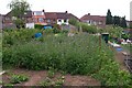
Kingsbury Road allotments, Allesley Park, Coventry.
Looking towards the backs of the houses in Donnington Avenue.
The block of blue plants in the foreground is Phacelia Tanacetefolia, a type of green manure plant that is normally cut down before flowering and dug into the ground to improve the soil, but in this case they have been left to flower as the bees and butterflies love them as they are a great source of nectar.
Image: © Peterson Cobbett
Taken: 9 May 2009
0.23 miles
8
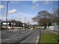
Hollyfast Road, Coundon (3)
Approaching the junction with Haynestone Road (left ahead).
Image: © Richard Vince
Taken: 2 Apr 2016
0.23 miles
9
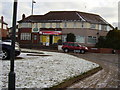
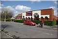
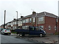
Just one left
1930's Corner shops now reduced to just one.
Image: © Anthony Vosper
Taken: 11 Feb 2010
0.24 miles
10
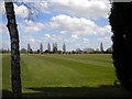
Playing fields, Coundon
Seen from Hollyfast Road.
Image: © Richard Vince
Taken: 2 Apr 2016
0.24 miles