IMAGES TAKEN NEAR TO
Sayer Drive, COVENTRY, CV5 9FA
Introduction
This page details the photographs taken nearby to Sayer Drive, CV5 9FA by members of the Geograph project.
The Geograph project started in 2005 with the aim of publishing, organising and preserving representative images for every square kilometre of Great Britain, Ireland and the Isle of Man.

There are currently over 7.5m images from over14,400 individuals and you can help contribute to the project by visiting https://www.geograph.org.uk
Image Map
Images are licensed for reuse under creativecommons.org/licenses/by-sa/2.0
Notes
- Clicking on the map will re-center to the selected point.
- The higher the marker number, the further away the image location is from the centre of the postcode.
Image Listing (7 Images Found)
Images are licensed for reuse under creativecommons.org/licenses/by-sa/2.0
Image
Details
Distance
1
Back of the Jag
Part of the ex Jaguar car plant buildings at Browns Lane, from Staircase Lane.
Image: © E Gammie
Taken: 6 Jan 2008
0.14 miles
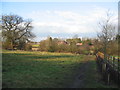
2
Footpath between Jaguar and Townfields
Looking towards the edge of Allesley at the allotments, centre and Butt Lane, right. Taken from the permissive footpath which runs between the nearly-defunct Jaguar plant (off to the left) and Townfields ( Image off to the right). The footpath is marked on 1977 editions (Pathfinder) of 1:25,000 Ordnance Survey. From here, it goes to the right, crosses the Sherbourne via a small wooden footbridge (visible, with no associated footpath, on the current 1:25,000 OS), then joins Butt Lane via a stile.
Image: © E Gammie
Taken: 1 Apr 2007
0.14 miles
3
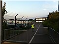
Off to work at BHX4
BHX4 is a 'receive centre' or 'cross dock facility' for Amazon goods. According to the Coventry Telegraph, everything sold by Amazon in the UK passes in and out of this facility, but the goods are not stored here for more than a few hours. Once processed, they are sent on to 'fulfilment centres' elsewhere in the UK 'and even Europe'. It is one of four Amazon sites in the Midlands, all named after the code for Birmingham Airport. The Telegraph reporter claims to have observed a 'fast-paced but good-natured atmosphere' in the building, which has three floors, each the size of eight football pitches. https://www.coventrytelegraph.net/news/coventry-news/coventry-news-amazon-coventry-warehouse-15580127
The receive centre is built on part of the site of the Jaguar Browns Lane plant, which made Jaguar cars between 1951 and 2005. This change of use is emblematic of the shift of employment in Coventry away from manufacturing to distribution and services.
Image: © A J Paxton
Taken: 8 Sep 2021
0.15 miles
4
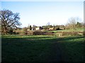
Townfields, Allesley
Taken from Butt Lane, Allesley. The trees behind Townfields, on the skyline, screen the Browns Lane Jaguar car plant, which will soon be no more.
2012: http://www.geograph.org.uk/photo/2784406
Image: © E Gammie
Taken: 7 Feb 2007
0.16 miles
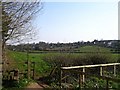
5
Townfields, Allesley
Comparison with a similar view in 2007, Image, shows that a fence has been installed and saplings planted to the right of the footpath.
Image: © E Gammie
Taken: 30 Jan 2012
0.18 miles
6
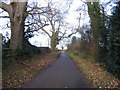
Staircase Lane
Staircase Lane is an undulating curving lane that runs from Allesley village to join Northbrook Road between Coundon and Brownshill Green. The two roads are both cut off by the Coundon Wedge road and are now mainly used by pedestrians and cyclists.
Image: © E Gammie
Taken: 6 Jan 2008
0.24 miles
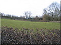
7
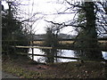
Pond by Staircase Lane
Allesley village in the background. Staircase Lane is an undulating curving lane that runs from Allesley village to join Northbrook Road between Coundon and Brownshill Green. The two roads are both cut off by the Coundon Wedge Road and are now mainly used by pedestrians and cyclists.
Image: © E Gammie
Taken: 6 Jan 2008
0.25 miles