IMAGES TAKEN NEAR TO
Rye Hill Office Park, Birmingham Road, COVENTRY, CV5 9AB
Introduction
This page details the photographs taken nearby to Rye Hill Office Park, Birmingham Road, CV5 9AB by members of the Geograph project.
The Geograph project started in 2005 with the aim of publishing, organising and preserving representative images for every square kilometre of Great Britain, Ireland and the Isle of Man.

There are currently over 7.5m images from over14,400 individuals and you can help contribute to the project by visiting https://www.geograph.org.uk
Image Map (Loading...)


Getting Data...Please wait
Leaflet Map data © OpenStreetMap
Images are licensed for reuse under creativecommons.org/licenses/by-sa/2.0
Notes
- Clicking on the map will re-center to the selected point.
- The higher the marker number, the further away the image location is from the centre of the postcode.
Image Listing (47 Images Found)
Images are licensed for reuse under creativecommons.org/licenses/by-sa/2.0
Image
Details
Distance
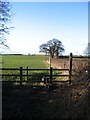
1
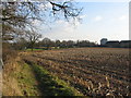
Stubble field and hotel
Looking towards Allesley on the footpath between Windmill Hill and Pickford. In the distance are houses on Windmill Hill and, to the right, the upper part of the Coventry Hill Hotel. The buildings on the extreme right are units on the small industrial estate by the A45.
Image: © E Gammie
Taken: 30 Jan 2012
0.04 miles
2
Footpath near Windmill Hill
Houses on Windmill Hill and a somewhat overgrown stile, the gateway to the right being used in preference.
Image: © E Gammie
Taken: 30 Jan 2012
0.06 miles
3
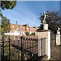
Quality Hotel, Allesley
Situated on the Birmingham Road on the western approach to Coventry, this building has a 1930s appearance, with a pair of Dutch gables and two pairs of gate piers topped with prancing horses. The A45 bypass, which runs past it, was built at this time.
Image: © A J Paxton
Taken: 15 Oct 2023
0.07 miles
4
The Quality Hotel, Birmingham Road, Allesley
Image: © habiloid
Taken: 28 Mar 2011
0.07 miles
5
Stile and hedgerow, Allesley
The start of the footpath, which follows the hedgerow, from Windmill Hill towards Pickford. The stiles on this path are of an 'in-line' type rather than on the diagonal (there is the alternative of a muddy gateway to the left of this stile).
Image: © E Gammie
Taken: 11 Feb 2007
0.07 miles
6
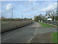
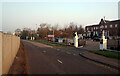
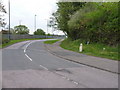
Birmingham Road, Allesley
Beside the busy A45.
Image: © JThomas
Taken: 4 Mar 2017
0.07 miles
7
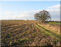
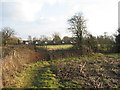
Stubble field near Allesley
The footpath from Windmill Hill towards Pickford follows the edge of this field.
The entrance to the path: Image
In 2007: Image
Image: © E Gammie
Taken: 30 Jan 2012
0.08 miles
8
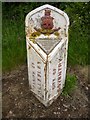
Old Boundary Marker by Birmingham Road, Coventry parish
Parish Boundary Marker by the UC road (was A45), in parish of Coventry (Coventry District), Birmingham Road, at junction with Windmill Hill, opposite hotel entrance on verge.
Inscription reads:-
: PARISH OF / ALLESLEY : : CITY OF / COVENTRY :
Surveyed
Milestone Society National ID: WA_COVAL2pb
Image: © Milestone Society
Taken: Unknown
0.09 miles
9
The City Boundary Marker on the Birmingham Road
The Boundary Marker, so eloquently and fully described in Image, at the roadside on the old Birmingham Road, Allesley. The old road has, for the most part, been subsumed by the A45 dual carriageway.
Image: © Richard Law
Taken: 14 Apr 2011
0.09 miles
