IMAGES TAKEN NEAR TO
Kilburn Drive, COVENTRY, CV5 8NN
Introduction
This page details the photographs taken nearby to Kilburn Drive, CV5 8NN by members of the Geograph project.
The Geograph project started in 2005 with the aim of publishing, organising and preserving representative images for every square kilometre of Great Britain, Ireland and the Isle of Man.

There are currently over 7.5m images from over14,400 individuals and you can help contribute to the project by visiting https://www.geograph.org.uk
Image Map (Loading...)


Getting Data...Please wait
Leaflet Map data © OpenStreetMap
Images are licensed for reuse under creativecommons.org/licenses/by-sa/2.0
Notes
- Clicking on the map will re-center to the selected point.
- The higher the marker number, the further away the image location is from the centre of the postcode.
Image Listing (216 Images Found)
Images are licensed for reuse under creativecommons.org/licenses/by-sa/2.0
Image
Details
Distance
1
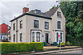
21 Allesley Old Road
House on Allesley Old Road, marked on the 1888 1:500 map as Hearsall House and on the 1905 edition as Florence House. It was originally a master watchmaker's house with a long workshop extension to the rear. Locally listed. The blue plaque by the door (see Image) reads: "1 Hearsall Terrace 21 Allesley Old Road Thomas & Rowland Hill Watch Manufacturers". The building is now occupied by a celebration balloon maker.
Image: © Ian Capper
Taken: 24 Sep 2021
0.04 miles
2
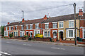
62 - 72 Allesley Old Road
Early 20th Century terrace, absent from the 1914 1:2,500 map but shown on the 1937 edition.
Image: © Ian Capper
Taken: 24 Sep 2021
0.04 miles
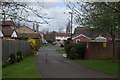
4
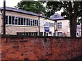
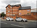
Former works entrance, Allesley Old Road
The access path to Rushmoor Drive is located where one of the works entrances to the Coventry (Renold) Chain factory stood. Beyond the wall to the right is a small garden on the site of Stanley Terrace, a short terrace of Victorian houses which stood at the junction of Allesley Old Road and Hearsall Lane.
Image: © E Gammie
Taken: 20 Dec 2013
0.05 miles
5
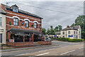
The Four Provinces and 21 Allesley Old Road
Buildings on Allesley Old Road, either side of Craven Street.
This side of the junction is The Four Provinces, marked on the 1888 and 1905 1:500 maps as Craven Lodge. It was bought by a group of Irish businessmen in the 1960s and opened in 1965 as a private members' club before becoming a pub in the early 2000s. See Image for a closer view.
On the other side is 21 Allesley Street, marked on the 1888 1:500 map as Hearsall House and on the 1905 edition as Florance House. It was originally a master watchmaker's house with a long workshop extension to the rear. The building is now occupied by a celebration balloon maker. See Image for a closer view.
Image: © Ian Capper
Taken: 24 Sep 2021
0.05 miles
6
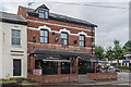
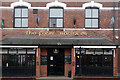
The Four Provinces
House on Allesley Old Road, marked on the 1888 and 1905 1:500 maps as Craven Lodge. It was bought by a group of Irish businessmen in the 1960s and opened in 1965 as a private members' club before becoming a pub in the early 2000s.
Image: © Ian Capper
Taken: 24 Sep 2021
0.05 miles
7
Workshop behind house
At the rear of a house facing on to Allesley Old Road and viewed from Craven Street, in the historic watchmaking district of Chapelfields.
Image: © A J Paxton
Taken: 29 Jul 2017
0.05 miles
9
The Four Provinces, Chapel Fields
With more claim to be genuinely Irish than the Irish-themed chain pubs that have appeared over the years, this establishment was opened as a private members' club by a group of Irish businessmen in the 1960s and has operated as a pub since the early 2000s. The front of the pub proudly proclaims it to be the 'four rovinces', the missing p can be seen on the roof above the door; compare with Image taken six weeks earlier when the p was still in place.
Image: © Stephen McKay
Taken: 5 Nov 2021
0.05 miles
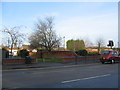
10
Coventry-The Four Provinces
Public House on the corner of Allesley Old Road and Craven Street. Built on the site of what is thought to have been a burial ground for lepers [http://news.bbc.co.uk/1/hi/england/coventry_warwickshire/6331147.stm]
Image: © Ian Rob
Taken: 21 Jul 2012
0.05 miles