IMAGES TAKEN NEAR TO
Kingsland Avenue, COVENTRY, CV5 8EB
Introduction
This page details the photographs taken nearby to Kingsland Avenue, CV5 8EB by members of the Geograph project.
The Geograph project started in 2005 with the aim of publishing, organising and preserving representative images for every square kilometre of Great Britain, Ireland and the Isle of Man.

There are currently over 7.5m images from over14,400 individuals and you can help contribute to the project by visiting https://www.geograph.org.uk
Image Map
Images are licensed for reuse under creativecommons.org/licenses/by-sa/2.0
Notes
- Clicking on the map will re-center to the selected point.
- The higher the marker number, the further away the image location is from the centre of the postcode.
Image Listing (155 Images Found)
Images are licensed for reuse under creativecommons.org/licenses/by-sa/2.0
Image
Details
Distance
1
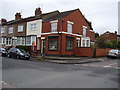
Corner Shop, Abercorn Road
This is in a quiet locality and one is tempted to speculate as to how long it will remain open.
Image: © Anthony Vosper
Taken: 28 Apr 2012
0.03 miles
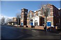
2
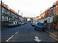
Kingsland Avenue
Buildings in Kingsland Avenue date from 1916-1924 and are mainly terraced with ground floor bay windows and a small distance between building line and pavement.
The trees just visible on the skyline are near Image .
Image: © E Gammie
Taken: 12 Jan 2012
0.03 miles
3
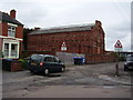
Hearsall, electricity sub station, Abercorn Road
Originally built for the city of Coventry in the 1930's to accommodate the new houses and industrial sites.
All Souls R C Primary school can just be viewed.
Image: © Anthony Vosper
Taken: 28 Apr 2012
0.04 miles
5
Hearsall Baptist Church Centre, Queensland Avenue
Image: © Keith Williams
Taken: 6 Apr 2008
0.05 miles
6
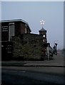
Hearsall Baptist church star
The simple Christmas-time decoration on the tower of the 1920s Sunday school buildings has been a part of the Chapelfields night sky for many years and was refurbished in 2003. Queensland Road with its recently pollarded trees to the right and in the foreground, the 1960s church building.
Image: © E Gammie
Taken: 31 Dec 2008
0.06 miles
7
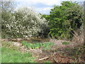
Small pond, Hearsall Common
A small pond in a corner of the common between the sub-station and the church. This area of the common is normally quite damp with frequent standing water. However, after a very dry April, the ground is merely spongy and this area looks quite dry.
Blackthorn in flower in the background.
Image: © E Gammie
Taken: 3 May 2013
0.06 miles
8
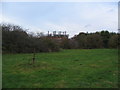
Hearsall Common
A corner of Hearsall Common and, beyond the brambles and spiked fence, the rear of the Abercorn Road sub-station. In the foreground, a metal remnant of something, possibly a bit of playground equipment.
Image: © E Gammie
Taken: 18 Nov 2011
0.06 miles
9
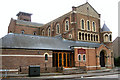
Church of the Precious Blood and All Souls, Kingsland Avenue
Image: © Niki Walton
Taken: 12 Oct 2007
0.06 miles
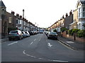
10
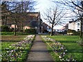
Crocuses and Kingsland Avenue
Taken from the path across the edge of Hearsall Common, between Hearsall Lane and the corner of Fife Road and Kingsland Avenue, looking down Kingsland Ave. The church on the left is All Souls, built in the 1920's.
Image: © E Gammie
Taken: 26 Feb 2007
0.07 miles