
IMAGES TAKEN NEAR TO
Craven Street, COVENTRY, CV5 8DW
Introduction
This page details the photographs taken nearby to Craven Street, CV5 8DW by members of the Geograph project.
The Geograph project started in 2005 with the aim of publishing, organising and preserving representative images for every square kilometre of Great Britain, Ireland and the Isle of Man.

There are currently over 7.5m images from over14,400 individuals and you can help contribute to the project by visiting https://www.geograph.org.uk
Image Map
Images are licensed for reuse under creativecommons.org/licenses/by-sa/2.0
Notes
- Clicking on the map will re-center to the selected point.
- The higher the marker number, the further away the image location is from the centre of the postcode.
Image Listing (198 Images Found)
Images are licensed for reuse under creativecommons.org/licenses/by-sa/2.0
Image
Details
Distance
1
Craven Street Garden
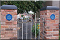
Entrance into Craven Street Garden, a small community garden at the corner of Craven Street and Mount Street (see Image). The blue plaques read: "Chapelfields. Where the watches ticked in long rows, the looms clacked and the bells rang. Home sweet Home. 1946". and "Craven St Garden. In dedication to the family who lost its home on this site, during the bombing of the 2nd World War".
Image: © Ian Capper
Taken: 24 Sep 2021
0.01 miles
3
Craven Street Garden
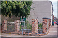
Small community garden at the corner of Craven Street and Mount Street, dedicated to the family who lost their house on the site during a World War II bombing raid.
Image: © Ian Capper
Taken: 24 Sep 2021
0.01 miles
4
The East Side of Lord Street
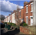
The terraced housing is typical of this area, most of it built in the 1850's.
Image: © Keith Williams
Taken: 21 Feb 2007
0.01 miles
5
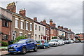
Craven Street
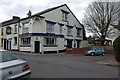
Mainly 19th Century housing. To the right of centre is the Chestnut Tree pub (see Image). A number of the buildings are locally listed.
Image: © Ian Capper
Taken: 24 Sep 2021
0.01 miles
6

The top of Mount Street
Terraced housing dating from the 19th century on the western edge of the Chapelfields watchmaking district.
Image: © E Gammie
Taken: 20 Dec 2013
0.01 miles
7
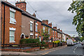
Mount Street
19th Century housing. Many of the buildings are locally listed, including 88 Craven Street, on the far left, then nos 31 - 32 Mount Street (the next building) and nos 34 - 37 (a few beyond). The blue plaque on no 35 (see Image), just visible in the centre of the photo, reads: "35 Mount Street. One of workshops of the Coventry Cooperative Watch Manufacturing Society Ltd set up by local watchmakers in 1876. About 1900 they moved to Stanley Terrace and ceased trading in 1918".
Image: © Ian Capper
Taken: 24 Sep 2021
0.02 miles
8
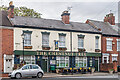
The Chestnut Tree
19th Century pub in Craven Street, first recorded in 1861 as the New Inn and renamed The Chestnut Tree in 1971, after a large Horse Chestnut Tree in the patio behind off Hearsall Lane. Locally listed. For a photo of its surrounds, see Image
Image: © Ian Capper
Taken: 24 Sep 2021
0.02 miles
9
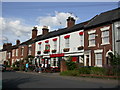
Coventry, The Chestnut Tree
Victorian terraced pub in Craven Street. Internally, central bar with drinking areas to left and right; pool and darts. Cask ales on offer at my visit: John Smith's Cask, Greene King Abbot, Wells Bombardier. For some customer comments, see http://www.beerintheevening.com/pubs/s/23/2388/Chestnut_Tree/Coventry
Image: © Mike Faherty
Taken: 3 Jul 2010
0.03 miles
10
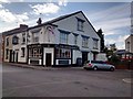
The Craven Arms, Craven Street
The Craven Arms is currently open, after briefly closing in 2013.
Image: © Keith Williams
Taken: 25 Apr 2015
0.03 miles