IMAGES TAKEN NEAR TO
Mount Street, COVENTRY, CV5 8DD
Introduction
This page details the photographs taken nearby to Mount Street, CV5 8DD by members of the Geograph project.
The Geograph project started in 2005 with the aim of publishing, organising and preserving representative images for every square kilometre of Great Britain, Ireland and the Isle of Man.

There are currently over 7.5m images from over14,400 individuals and you can help contribute to the project by visiting https://www.geograph.org.uk
Image Map
Images are licensed for reuse under creativecommons.org/licenses/by-sa/2.0
Notes
- Clicking on the map will re-center to the selected point.
- The higher the marker number, the further away the image location is from the centre of the postcode.
Image Listing (193 Images Found)
Images are licensed for reuse under creativecommons.org/licenses/by-sa/2.0
Image
Details
Distance
1
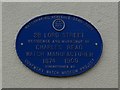
Coventry Watch Museum Project plaque on 28 Lord Street
Image: © Keith Williams
Taken: 28 Mar 2009
0.01 miles
2
28 Lord Street
A former watch making premises, identified by the Coventry Watch Museum Project plaque, shown here Image
This is the 17th site on the Coventry Watchmakers' Heritage Trail.
The next site on the trail is Image
The prior site on the trail is Image
Image: © Keith Williams
Taken: 28 Mar 2009
0.02 miles
3
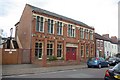
Factory on Lord Street
This was built originally as a Baptist Sunday School, until the Baptist Church moved to the current building: Image
Image: © Keith Williams
Taken: 28 Mar 2009
0.02 miles
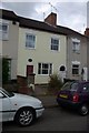
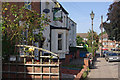
5
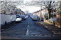
Mount Street, Coventry
At the far end of this road can just be seen the Chestnut Tree pub, which is on Craven Street.
Image: © Keith Williams
Taken: 6 Apr 2008
0.03 miles
6
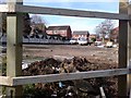
Redevelopment Site, Allesley Old Road
This site was previously a Jet petrol station, and is currently in the process of being redeveloped into apartments. The houses in the background are on Mount Street.
Image: © Keith Williams
Taken: 19 Mar 2008
0.03 miles
7
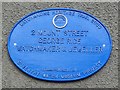
Coventry Watch Museum Project plaque on 2 Mount Street
Image: © Keith Williams
Taken: 4 Apr 2009
0.03 miles
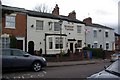
8
Lord Street
19th Century hall and houses. The building on the left, nos 22 - 25, is a former Sunday School, opened in 1861. It closed in 1928 when the school moved to Queensland Avenue and the building was converted into a factory. It was subsequently converted to housing in 2012, the development being named The Watchmakers, a fitting title given the historic industry of the area. Locally listed.
Image: © Ian Capper
Taken: 24 Sep 2021
0.04 miles
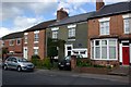
9
The Nursery Tavern, Chapel Fields
Traditional pub on Lord Street, just off Allesley Old Road.
Image: © Stephen McKay
Taken: 15 Sep 2012
0.04 miles
10
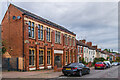
2 Mount Street
A former watch making premises, identified by the Coventry Watch Museum Project plaque, shown here Image
This is the 14th site on the Coventry Watchmakers' Heritage Trail.
The next site on the trail is Image
The prior site on the trail is Image
Image: © Keith Williams
Taken: 4 Apr 2009
0.04 miles