
IMAGES TAKEN NEAR TO
Allesley Old Road, COVENTRY, CV5 8BY
Introduction
This page details the photographs taken nearby to Allesley Old Road, CV5 8BY by members of the Geograph project.
The Geograph project started in 2005 with the aim of publishing, organising and preserving representative images for every square kilometre of Great Britain, Ireland and the Isle of Man.

There are currently over 7.5m images from over14,400 individuals and you can help contribute to the project by visiting https://www.geograph.org.uk
Image Map
Images are licensed for reuse under creativecommons.org/licenses/by-sa/2.0
Notes
- Clicking on the map will re-center to the selected point.
- The higher the marker number, the further away the image location is from the centre of the postcode.
Image Listing (215 Images Found)
Images are licensed for reuse under creativecommons.org/licenses/by-sa/2.0
Image
Details
Distance
1
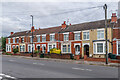
62 - 72 Allesley Old Road
Early 20th Century terrace, absent from the 1914 1:2,500 map but shown on the 1937 edition.
Image: © Ian Capper
Taken: 24 Sep 2021
0.01 miles
3

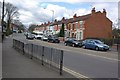
31 - 49 Allesley Old Road
19th Century watchmakers' terrace. The nearest two buildings, nos 31 and 33, are locally listed. The blue plaque between the doors (see Image) reads: "1 Russell Terrace 31 Allesley Old Road William Henry Hill Watch manufacturer".
Image: © Ian Capper
Taken: 24 Sep 2021
0.03 miles
4
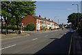
Allesley Old Road, Chapel Fields
Heading in towards the city centre along the B4106.
Image: © Stephen McKay
Taken: 15 Sep 2012
0.03 miles
5
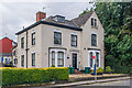
21 Allesley Old Road
House on Allesley Old Road, marked on the 1888 1:500 map as Hearsall House and on the 1905 edition as Florence House. It was originally a master watchmaker's house with a long workshop extension to the rear. Locally listed. The blue plaque by the door (see Image) reads: "1 Hearsall Terrace 21 Allesley Old Road Thomas & Rowland Hill Watch Manufacturers". The building is now occupied by a celebration balloon maker.
Image: © Ian Capper
Taken: 24 Sep 2021
0.04 miles
6
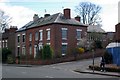
House on the corner of Duke Street
The house is an old watch factory. The watches would have been worked on in the well-lit extension at the back of the house.
Image: © Keith Williams
Taken: 28 Mar 2009
0.04 miles
7
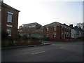
Derelict watch factory, rebuilt
The former watch factory behind 31 Allesley Old Road, after lying empty for several years, had got into a ruinous state by 2009 ( Image] ). Since then it has been completely demolished and rebuilt with a slight change to its window line. In the 1960s it was occupied by an electronics firm and had an immaculately kept garden.
Image: © E Gammie
Taken: 20 Dec 2013
0.04 miles
8
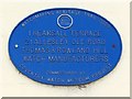
Coventry Watch Museum Project plaque on 21 Allesley Old Road
Image: © Keith Williams
Taken: 4 Apr 2009
0.04 miles
9
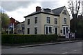
21 Allesley Old Road
A former watch making premises, identified by the Coventry Watch Museum Project plaque, shown here Image
This is the 9th site on the Coventry Watchmakers' Heritage Trail.
The next site on the trail is Image
The prior site on the trail is Image
Image: © Keith Williams
Taken: 4 Apr 2009
0.04 miles
10
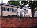
Workshop behind house
At the rear of a house facing on to Allesley Old Road and viewed from Craven Street, in the historic watchmaking district of Chapelfields.
Image: © A J Paxton
Taken: 29 Jul 2017
0.04 miles