IMAGES TAKEN NEAR TO
Larkfield Way, COVENTRY, CV5 7QB
Introduction
This page details the photographs taken nearby to Larkfield Way, CV5 7QB by members of the Geograph project.
The Geograph project started in 2005 with the aim of publishing, organising and preserving representative images for every square kilometre of Great Britain, Ireland and the Isle of Man.

There are currently over 7.5m images from over14,400 individuals and you can help contribute to the project by visiting https://www.geograph.org.uk
Image Map
Images are licensed for reuse under creativecommons.org/licenses/by-sa/2.0
Notes
- Clicking on the map will re-center to the selected point.
- The higher the marker number, the further away the image location is from the centre of the postcode.
Image Listing (34 Images Found)
Images are licensed for reuse under creativecommons.org/licenses/by-sa/2.0
Image
Details
Distance
1
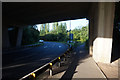
A45 goes over the top of the A4114 at Allesley Green
Image: © Ian S
Taken: 29 Aug 2019
0.09 miles
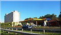
3
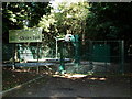
Allesley Park Sewage Pumping Station
Accessed off Park Hill Lane adjacent to the A45 roundabout.
The sign is some years old as it gives a Severn Trent telephone number starting in 0203 - the code for Coventry has changed twice since then - to 01203 and then to 024 76.
Image: © John Brightley
Taken: 31 Aug 2010
0.11 miles
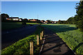
7
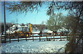
Snow clearance at Pickford Way
Sunday 9th December 1990, the morning after a major snowfall paralysed the roads in the area. The Dunchurch Highway (A45) between here, the Pickford Way junction, and Broad Lane was closed overnight due to several vehicles having been unable to negotiate the undulating profile. Work is under way to clear the road and free the vehicles stuck here overnight.
Image: © E Gammie
Taken: 9 Dec 1990
0.15 miles
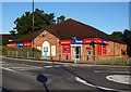
8
Petrol Station near the Coventry Hill Hotel
Image: © Anthony Parkes
Taken: 17 Oct 2013
0.15 miles
9
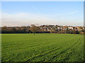
Allesley village and Coventry Hill Hotel
Taken from Allesley Park (foreground). Coventry Hill Hotel centre horizon, Allesley village to the right. The houses shown were built during the expansion of the village in the latter half of the 20th century. It is within the Coventry boundary but maintains an independent character.
Image: © E Gammie
Taken: 15 Nov 2007
0.15 miles
10
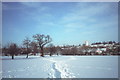
Allesley Park in the snow
Sunday 9th December 1990, the morning after a major snowfall paralysed the roads in the area. Looking towards Pickford Way where work is under way to free vehicles that have been stuck there overnight. Coventry Hill hotel on the horizon.
A similar snow-free view taken from further south-east : http://www.geograph.org.uk/photo/613370
Image: © E Gammie
Taken: 9 Dec 1990
0.19 miles