IMAGES TAKEN NEAR TO
Dunchurch Highway, COVENTRY, CV5 7PD
Introduction
This page details the photographs taken nearby to Dunchurch Highway, CV5 7PD by members of the Geograph project.
The Geograph project started in 2005 with the aim of publishing, organising and preserving representative images for every square kilometre of Great Britain, Ireland and the Isle of Man.

There are currently over 7.5m images from over14,400 individuals and you can help contribute to the project by visiting https://www.geograph.org.uk
Image Map
Images are licensed for reuse under creativecommons.org/licenses/by-sa/2.0
Notes
- Clicking on the map will re-center to the selected point.
- The higher the marker number, the further away the image location is from the centre of the postcode.
Image Listing (37 Images Found)
Images are licensed for reuse under creativecommons.org/licenses/by-sa/2.0
Image
Details
Distance
1
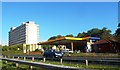
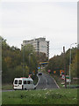
Petrol Station near the Coventry Hill Hotel
Image: © Anthony Parkes
Taken: 17 Oct 2013
0.06 miles
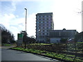
2
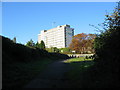
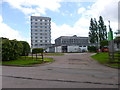
Coventry Hill Hotel, Rye Hill
The top of Park Hill Lane, now cut off, and the hotel on the other side of the A45. Park Hill Lane was the route from Eastern Green to the Windmill Hill end of Allesley until the A45 southern bypass was built and the pre-existing road between Allesley and Meriden was made dual carriageway. It continued to be open to through traffic travelling in a westerly direction until the 1970s.
Image: © E Gammie
Taken: 10 Oct 2010
0.06 miles
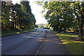
3
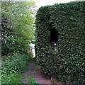
Footpath alongside Windmill Village Golf Club, Allesley
The footpath runs down the slope from the A45 dual carriageway to a footbridge over the Pickford Brook, where it forks, with paths continuing to Lower and to Upper Eastern Green. The footpath marker has been overgrown by the hedge surrounding the golf course, but a Henry Moore hole has been cut in the hedge to reveal it. The A45 is a formidable barrier to pedestrians here and is too dangerous to cross on foot.
Image: © A J Paxton
Taken: 4 May 2023
0.08 miles
5
Coventry Hill Hotel, whilst waiting in a queue!
A usual queue from the A45 to head towards Coundon Wedge. The Coventry Hill Hotel is over the roundabout, with the fabulous one way only garage just visible.
Image: © Richard Harrison
Taken: 30 Oct 2005
0.08 miles
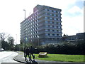
8
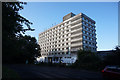
Britannia Coventry Hill Hotel
View from Birmingham Road, Allesley.
Image: © JThomas
Taken: 4 Mar 2017
0.09 miles
9
Coventry Hill Hotel
On Birmingham Road: http://www.britanniahotels.com/hotels/coventry-hill/
Image: © Mike Faherty
Taken: 7 Jun 2014
0.09 miles
10
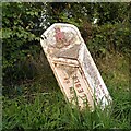
Boundary Marker by Birmingham Road, Allesley
This cast iron post marks the boundary between the city of Coventry and the parish of Allesley from 1st April 1926, when Coventry was extended westward with the purchase of land from the Stoneleigh estate, which was to become the western suburbs of the city. In 1974 Allesley, too, became part of Coventry, though it retains its own parish council.
Image: © A J Paxton
Taken: 15 Oct 2023
0.11 miles