IMAGES TAKEN NEAR TO
Church Lane, COVENTRY, CV5 7BX
Introduction
This page details the photographs taken nearby to Church Lane, CV5 7BX by members of the Geograph project.
The Geograph project started in 2005 with the aim of publishing, organising and preserving representative images for every square kilometre of Great Britain, Ireland and the Isle of Man.

There are currently over 7.5m images from over14,400 individuals and you can help contribute to the project by visiting https://www.geograph.org.uk
Image Map (Loading...)


Getting Data...Please wait
Leaflet Map data © OpenStreetMap
Images are licensed for reuse under creativecommons.org/licenses/by-sa/2.0
Notes
- Clicking on the map will re-center to the selected point.
- The higher the marker number, the further away the image location is from the centre of the postcode.
Image Listing (18 Images Found)
Images are licensed for reuse under creativecommons.org/licenses/by-sa/2.0
Image
Details
Distance
1
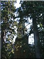
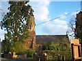
St Andrews church, Eastern Green
The spire of St Andrews, almost hidden behind two Scots pines.
Image: © E Gammie
Taken: 10 Oct 2010
0.02 miles
2
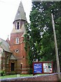
The parish church of St Andrew, Eastern Green
The church was established in 1875.
Image: © Keith Williams
Taken: 19 Jun 2008
0.02 miles
4
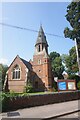
Eastern Green Church
St Andrew dating from 1875.
Image: © Ian Rob
Taken: 1 Aug 2019
0.02 miles
5
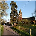
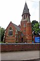
St Andrew's Church, Eastern Green
This parish church of the Church of England stands on the western edge of Coventry, surrounded by fields. A red brick building in the Gothic revival style, it opened in 1875, according to the parish website, which doesn't mention the name of the architect https://standrewseg.co.uk/information/history-of-st-andrews-church/ .
Two Giant Sequoia (Sequoiadendron giganteum) trees, otherwise known as Giant Redwood or Wellingtonia, were planted in the churchyard, on either side of the path from gate to church. One has been felled and only a huge stump remains. The other now towers over the church, and can be seen to the left of the steeple.
Image: © A J Paxton
Taken: 28 Apr 2023
0.03 miles
6
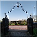
Gate, St Andrew's Church, Eastern Green
Upper Eastern Green Lane can be seen through the churchyard gates and their decorative lamp overthrow. For more on the church itself see Image
Image: © A J Paxton
Taken: 28 Apr 2023
0.03 miles
7
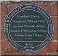
Plaque at St Andrew's Church, Upper Eastern Green
Image: © Ian S
Taken: 26 Jul 2021
0.04 miles
8
St Andrew's C of E Church, Church Lane, Eastern Green, Coventry
Image: © Susan Vickery
Taken: 1 May 2013
0.04 miles
9
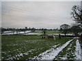
Farmland Near Upper Eastern Green
On the skyline (left) you can just see the Agco (ex Massey Ferguson) tower block. Further right on the skyline are three large conifers obscuring St. Andrew's Church, Eastern Green.
Image: © John Winterbottom
Taken: 28 Dec 2005
0.05 miles
10
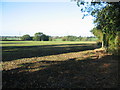
Farmland, Eastern Green
The land opposite St Andrews church drops away to a brook at the trees, then rises towards Pickford Grange farm and Pickford Green.
Image: © E Gammie
Taken: 10 Oct 2010
0.09 miles