IMAGES TAKEN NEAR TO
Troutbeck Road, COVENTRY, CV5 7BQ
Introduction
This page details the photographs taken nearby to Troutbeck Road, CV5 7BQ by members of the Geograph project.
The Geograph project started in 2005 with the aim of publishing, organising and preserving representative images for every square kilometre of Great Britain, Ireland and the Isle of Man.

There are currently over 7.5m images from over14,400 individuals and you can help contribute to the project by visiting https://www.geograph.org.uk
Image Map
Images are licensed for reuse under creativecommons.org/licenses/by-sa/2.0
Notes
- Clicking on the map will re-center to the selected point.
- The higher the marker number, the further away the image location is from the centre of the postcode.
Image Listing (28 Images Found)
Images are licensed for reuse under creativecommons.org/licenses/by-sa/2.0
Image
Details
Distance
2
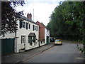
Old Cottages, Lower Eastern Green, Coventry
A row of original cottages in Unicorn Lane that pre-date the more modern housing development which has now covered this square.
Image: © David Stowell
Taken: 29 Aug 2005
0.05 miles
3
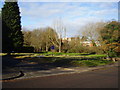
Good Shepherd Lutheran Church, Lower Eastern Green
A modern building, situated on Job's Lane.
Image: © David Stowell
Taken: 29 Aug 2005
0.05 miles
4
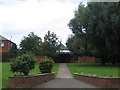
Entrance to Eastern Green Lutheran Church
The near by close is also named after Luther.
Their front lawn sadly is in need of a little TLC.
Image: © Anthony Vosper
Taken: 7 Dec 2013
0.06 miles
5
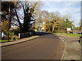
Bridge over the Brookstray
A small tributary of Coventry's main River Sherbourne.
Situated on Upper Eastern Green Lane.
The car park of the Unicorn Public house can be just seen in the background.
Image: © Anthony Vosper
Taken: 7 Dec 2013
0.07 miles


8
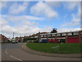
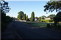
Unicorn Avenue, Lower Eastern Green
The junction with Eastern Green Road showing a row of local shops and some of the 1960s & 70s housing that covers much of this square.
Image: © David Stowell
Taken: 29 Aug 2005
0.10 miles
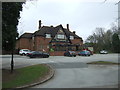
10
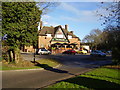
The Unicorn, Eastern Green
Part of The Hungry Horse chain of restaurants.
Situated on Unicorn Lane. GPS units currently do not tell you that the lane is now blocked half way.
Image: © Anthony Vosper
Taken: 7 Dec 2013
0.11 miles