IMAGES TAKEN NEAR TO
Broad Lane, COVENTRY, CV5 7BA
Introduction
This page details the photographs taken nearby to Broad Lane, CV5 7BA by members of the Geograph project.
The Geograph project started in 2005 with the aim of publishing, organising and preserving representative images for every square kilometre of Great Britain, Ireland and the Isle of Man.

There are currently over 7.5m images from over14,400 individuals and you can help contribute to the project by visiting https://www.geograph.org.uk
Image Map (Loading...)


Getting Data...Please wait
Leaflet Map data © OpenStreetMap
Images are licensed for reuse under creativecommons.org/licenses/by-sa/2.0
Notes
- Clicking on the map will re-center to the selected point.
- The higher the marker number, the further away the image location is from the centre of the postcode.
Image Listing (5 Images Found)
Images are licensed for reuse under creativecommons.org/licenses/by-sa/2.0
Image
Details
Distance
1
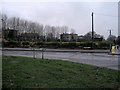
The Hawthorn Tree has gone
The Hawthorn Tree public house which used to stand here was demolished in November 2008. All that remains is a pile of rubble and a view through the trees of flats and the tower block on the ex-Massey Ferguson site in Banner Lane (SP2779).
Earlier in 2008 : Image
New houses, 2011: Image]
Image: © E Gammie
Taken: 13 Dec 2008
0.05 miles
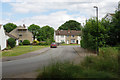
2
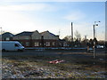
Hawthorn Lane junction with Broad Lane
New houses on the site of the Hawthorn Tree public house and its car park.
See also: Image] and Image]
Image: © E Gammie
Taken: 21 Jan 2011
0.05 miles
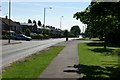
5
Delius Street, Tile Hill
Seen from the junction with Hawthorn Lane in Coventry's western suburbs.
Image: © Stephen McKay
Taken: 14 Jul 2017
0.23 miles