IMAGES TAKEN NEAR TO
Broad Lane, COVENTRY, CV5 7AB
Introduction
This page details the photographs taken nearby to Broad Lane, CV5 7AB by members of the Geograph project.
The Geograph project started in 2005 with the aim of publishing, organising and preserving representative images for every square kilometre of Great Britain, Ireland and the Isle of Man.

There are currently over 7.5m images from over14,400 individuals and you can help contribute to the project by visiting https://www.geograph.org.uk
Image Map (Loading...)


Getting Data...Please wait
Leaflet Map data © OpenStreetMap
Images are licensed for reuse under creativecommons.org/licenses/by-sa/2.0
Notes
- Clicking on the map will re-center to the selected point.
- The higher the marker number, the further away the image location is from the centre of the postcode.
Image Listing (78 Images Found)
Images are licensed for reuse under creativecommons.org/licenses/by-sa/2.0
Image
Details
Distance
1
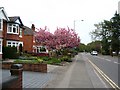
Cherry blossom, Broad Lane
A colourful display in the front garden of one of the 1920s semis on Broad Lane.
Image: © E Gammie
Taken: 29 Apr 2010
0.01 miles
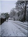
2
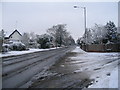
Broad Lane in snow
The morning after an overnight snowfall of 2-3 inches. Keep well back to avoid the slush spray from passing traffic.
Image: © E Gammie
Taken: 5 Feb 2009
0.02 miles
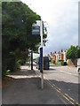
3
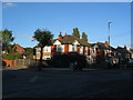
Closed Post Office
The post office at the corner of Broad Lane and Glendower Avenue has recently closed down and stands shuttered with its signage painted out.
When first built, in the 1920s, both this and the adjoining house had ground floor shops, with the last occupant of the right hand shop before its conversion back to residential use being a small grocer's store.
To the right is a bus stop with no route to serve, presumably retained in case a bus operator decides to re-introduce a service.
Since this photo was taken, the postbox has been re-sited in Hendre Close on the other side of Broad Lane (see Image] ).
Image: © E Gammie
Taken: 26 Sep 2015
0.04 miles
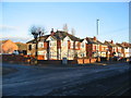
4
Post Office on the junction of Glendower Avenue and Broad Lane
Image: © Keith Williams
Taken: 23 Jun 2008
0.05 miles
5
Bus stop, not in use, Broad Lane
However it "may still be observed by certain school or college services". No bus service runs down this section of Broad Lane since the removal of the 34 service in February 2012.
Image: © E Gammie
Taken: 29 Jun 2012
0.05 miles
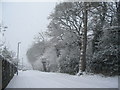
6
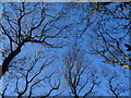
Guphill Avenue in snow
Guphill Avenue is lined with 1930s housing on one side and the deciduous woodland of Hearsall Common on the other. On old OS maps Guphill Avenue is shown as Whoberley Lane and was the main approach to Whoberley Hall.
Image: © E Gammie
Taken: 5 Feb 2009
0.05 miles
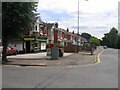
7
Broad Lane
The former Post Office / corner shop at the junction of Glendower Avenue and Broad Lane ( Image] ) has been converted to flats.
Image: © E Gammie
Taken: 1 Dec 2016
0.05 miles
8
Guphill Avenue
The snow had been falling steadily all morning and was about 10cm deep by this time.
The trees on the right are part of Hearsall Common woodland. This road, formerly an approach lane to Whoberley Hall, was, between 1842 and the boundary extensions of 1928, on the western boundary of the city.
Image: © E Gammie
Taken: 18 Jan 2013
0.05 miles
9
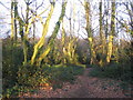
Hearsall Common
Afternoon sun, very welcome at the end of a pretty dull and wet January.
Image: © E Gammie
Taken: 27 Jan 2008
0.06 miles
10
Hearsall Common, Christmas 2009
Just before 1pm on Christmas Day 2009. Not a cloud in the sky on a bright sunny day after a week of freezing conditions. A slow thaw setting in.
In comparison, the gloomy conditions of Christmas 2007: http://www.geograph.org.uk/photo/640119 .
Image: © E Gammie
Taken: 25 Dec 2009
0.07 miles