
IMAGES TAKEN NEAR TO
Broadwater, COVENTRY, CV5 6QQ
Introduction
This page details the photographs taken nearby to Broadwater, CV5 6QQ by members of the Geograph project.
The Geograph project started in 2005 with the aim of publishing, organising and preserving representative images for every square kilometre of Great Britain, Ireland and the Isle of Man.

There are currently over 7.5m images from over14,400 individuals and you can help contribute to the project by visiting https://www.geograph.org.uk
Image Map
Images are licensed for reuse under creativecommons.org/licenses/by-sa/2.0
Notes
- Clicking on the map will re-center to the selected point.
- The higher the marker number, the further away the image location is from the centre of the postcode.
Image Listing (116 Images Found)
Images are licensed for reuse under creativecommons.org/licenses/by-sa/2.0
Image
Details
Distance
1
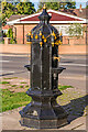
Earlsdon Drinking Fountain
19th Century drinking fountain situated on Earlsdon Avenue as it leaves Stivichall Common. Manufactured by George Smith & Sons of Glasgow in the 1860s, it was originally sited outside St John the Baptist's Church in central Coventry, moving here in 1921 after the opening of nearby War Memorial Park. Grade II listed - see www.historicengland.org.uk/listing/the-list/list-entry/1443610. For a wider view, see Image
Image: © Ian Capper
Taken: 24 Sep 2021
0.05 miles
2
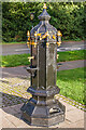
Earlsdon Drinking Fountain
19th Century drinking fountain situated on Earlsdon Avenue as it leaves Stivichall Common. Manufactured by George Smith & Sons of Glasgow in the 1860s, it was originally sited outside St John the Baptist's Church in central Coventry, moving here in 1921 after the opening of nearby War Memorial Park. Grade II listed - see www.historicengland.org.uk/listing/the-list/list-entry/1443610. For a wider view, see Image
Image: © Ian Capper
Taken: 24 Sep 2021
0.05 miles
3
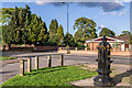
Earlsdon Avenue
Looking across Earlsdon Avenue as it leaves Stivichall Common. For close ups of the drinking fountain on the right, see Image and Image
Image: © Ian Capper
Taken: 24 Sep 2021
0.06 miles
4
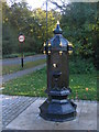
Restored drinking fountain
The drinking fountain on Earlsdon Avenue South has been restored in 2015 complete with water supply. The water from the taps drains via the upper bowls down to a reservoir in the base available to passing dogs, cats and what have you.
In 2008: Image]
As can be seen from a comparison of the two photos it has been turned through 90 degrees and is slightly further away from the road. According to the Historic England listing the fountain is one (and the only operational) of two surviving drinking fountains of this type manufactured by George Smith & Co. at the Sun Foundry, Glasgow. It was originally erected in 1870 outside Image] in the city centre (visible in a Francis Frith postcard of c. 1884, when it appears to have been surmounted by a lamp) and later moved to this location in 1921 after the opening of the nearby Memorial Park. It was reputedly in operation until the 1970s although I can't recall it working in the 1960s.
The other fountain can be seen here: Image] (2008) and a closer view (repainted) in 2017: Image]
Another very similar casting: Image]
and two others with similar bases: Image] (Faversham, 2014) and Image] (2005)
External links :
Original location (Frith): https://www.francisfrith.com/coventry/coventry-church-of-st-john-the-baptist-c1884_17127
Historic England listing: https://historicengland.org.uk/listing/the-list/list-entry/1443610
Image: © E Gammie
Taken: 26 Oct 2015
0.06 miles
5
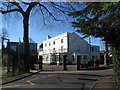
School building in The Firs
One of the buildings housing King Henry VIII preparatory school, an independent school associated with the nearby King Henry VIII secondary school.
Image: © E Gammie
Taken: 16 Mar 2014
0.07 miles
6
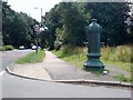
Drinking fountain on Earlsden Avenue South
There is currently a fund raising effort in progress to get this drinking fountain restored.
Image: © Keith Williams
Taken: 1 Jul 2008
0.08 miles
7
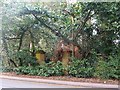
Old gate pillars, Kenilworth Road
A disused gateway on Kenilworth Road. Ordnance survey maps dated 1892-1914 show a drive to a large property called Broadwater (which no longer exists) at this point.
Image: © E Gammie
Taken: 31 Jan 2019
0.08 miles
8
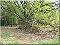
Edge of Stivichall Common
There are several of these "Eeyore's house" constructions scattered around the woodland.
Image: © E Gammie
Taken: 1 May 2021
0.08 miles
9

A429 approaching Coventry
There is an OS benchmark Image on top of the milestone which indicates Coventry 1 Warwick 9
Image: © Roger Templeman
Taken: 3 May 2016
0.09 miles
10

Old Milestone by the A429, Kenilworth Road, Coventry Parish
Metal plate attached to stone post by the A429, in parish of COVENTRY (COVENTRY District), Kenilworth Road, 50m East of junction with Earlsdon Avenue South, on the verge in woodland, on South side of road, opposite bus stop. Erected by the Coventry & Warwick turnpike trust in the 19th century.
Inscription reads:-
TO
COVENTRY
1 MILE
TO
WARWICK
9
MILES
Coventry HER.
HER no.: MCT16328 https://www.heritagegateway.org.uk/Gateway/Results_Single.aspx?uid=MCT16328&resourceID=1029
Milestone Society National ID: WA_CVWA01.
Image: © M Faherty
Taken: 12 Mar 2011
0.09 miles