IMAGES TAKEN NEAR TO
Broadway, COVENTRY, CV5 6NU
Introduction
This page details the photographs taken nearby to Broadway, CV5 6NU by members of the Geograph project.
The Geograph project started in 2005 with the aim of publishing, organising and preserving representative images for every square kilometre of Great Britain, Ireland and the Isle of Man.

There are currently over 7.5m images from over14,400 individuals and you can help contribute to the project by visiting https://www.geograph.org.uk
Image Map (Loading...)


Getting Data...Please wait
Leaflet Map data © OpenStreetMap
Images are licensed for reuse under creativecommons.org/licenses/by-sa/2.0
Notes
- Clicking on the map will re-center to the selected point.
- The higher the marker number, the further away the image location is from the centre of the postcode.
Image Listing (83 Images Found)
Images are licensed for reuse under creativecommons.org/licenses/by-sa/2.0
Image
Details
Distance
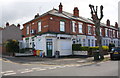
1
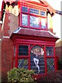
The Broadway Melody
Window decorations in house on Broadway, Earlsdon, Coventry. Part of a local project in early 2021 to raise spirits during the coronavirus pandemic lockdown restrictions.
Image: © A J Paxton
Taken: 27 Feb 2021
0.02 miles
2
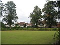
Spencer Park
Looking across the bowling green at Spencer Park towards houses on Broadway.
Image: © E Gammie
Taken: 11 Sep 2020
0.05 miles
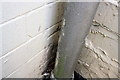
3
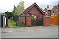
Electricity substation on Mayfield Road
There is an OS benchmark Image on the short wall to the left of the ESS gates
Image: © Roger Templeman
Taken: 3 May 2016
0.06 miles
4
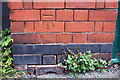
Benchmark on ESS wall, Mayfield Road
Ordnance Survey cut mark benchmark described on the Bench Mark Database at http://www.Bench-marks.org.uk/bm75417
Image: © Roger Templeman
Taken: 3 May 2016
0.06 miles
5
Houses and wine shop at Mayfield Road / Huntingdon Road junction
There is an OS benchmark Image tucked away on the wall of the shop where the hedge-topped wall abuts.
Image: © Roger Templeman
Taken: 3 May 2016
0.08 miles
6
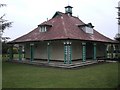
Coventry-Spencer Park
Pavilion in the park.
Image: © Ian Rob
Taken: 23 Jan 2011
0.09 miles
7
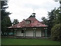
Spencer Park pavilion
Looking slightly dilapidated but cared for by the Friends of Spencer Park volunteers, the pavilion dates from 1915.
Image: © E Gammie
Taken: 11 Sep 2020
0.09 miles
8
Benchmark on #27 Mayfield Road
Ordnance Survey cut mark benchmark described on the Bench Mark Database at http://www.bench-marks.org.uk/bm75418
Image: © Roger Templeman
Taken: 3 May 2016
0.09 miles
9
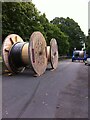
Cable laying, Spencer Avenue, Earlsdon
Cable laying in July 2014 in the Coventry suburb of Earlsdon.
Image: © A J Paxton
Taken: 14 Jul 2014
0.12 miles
10
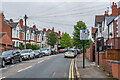
Spencer Avenue
Mainly early 20th Century housing, some first shown on the 1914 25 inch map.
Image: © Ian Capper
Taken: 25 Sep 2021
0.13 miles