IMAGES TAKEN NEAR TO
Alan Marcell Close, COVENTRY, CV4 9YJ
Introduction
This page details the photographs taken nearby to Alan Marcell Close, CV4 9YJ by members of the Geograph project.
The Geograph project started in 2005 with the aim of publishing, organising and preserving representative images for every square kilometre of Great Britain, Ireland and the Isle of Man.

There are currently over 7.5m images from over14,400 individuals and you can help contribute to the project by visiting https://www.geograph.org.uk
Image Map
Images are licensed for reuse under creativecommons.org/licenses/by-sa/2.0
Notes
- Clicking on the map will re-center to the selected point.
- The higher the marker number, the further away the image location is from the centre of the postcode.
Image Listing (23 Images Found)
Images are licensed for reuse under creativecommons.org/licenses/by-sa/2.0
Image
Details
Distance
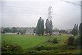
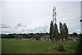
4
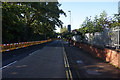
Wolfe Road
Wolfe Road runs south from Torrington Avenue to Charter Avenue via a narrow underbridge carrying the Coventry to Birmingham rail line.
Image: © E Gammie
Taken: 23 May 2010
0.13 miles
9
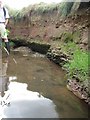
Strata exposed in the bank of the Canley Brook, Canley, Coventry
Below the top layer of glacial deposit are layers of sandstone, Mercia Mudstone and pebbles that speak of flash floods and seasonal lakes in a desert environment.
Image: © Robin Stott
Taken: 3 Aug 2013
0.18 miles
10

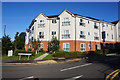
In place of Tile Hill College
A housing development on the old Tile Hill College site, Tile Hill Lane.
See also: http://www.geograph.org.uk/photo/48236 (2005)
and http://www.geograph.org.uk/photo/838733 (2008)
Image: © E Gammie
Taken: 23 Aug 2010
0.19 miles