IMAGES TAKEN NEAR TO
Heronbank, COVENTRY, CV4 9XN
Introduction
This page details the photographs taken nearby to Heronbank, CV4 9XN by members of the Geograph project.
The Geograph project started in 2005 with the aim of publishing, organising and preserving representative images for every square kilometre of Great Britain, Ireland and the Isle of Man.

There are currently over 7.5m images from over14,400 individuals and you can help contribute to the project by visiting https://www.geograph.org.uk
Image Map
Images are licensed for reuse under creativecommons.org/licenses/by-sa/2.0
Notes
- Clicking on the map will re-center to the selected point.
- The higher the marker number, the further away the image location is from the centre of the postcode.
Image Listing (6 Images Found)
Images are licensed for reuse under creativecommons.org/licenses/by-sa/2.0
Image
Details
Distance
1
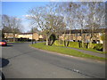
Goodman Way, Tanyard Farm estate
About halfway between Tanner's Lane and Banner Lane.
Image: © Richard Vince
Taken: 2 Apr 2016
0.16 miles
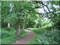
3

Bus turning circle, Tanyard Farm estate
The terminus of routes 6 and 6A on Goodman Way.
Image: © Richard Vince
Taken: 2 Apr 2016
0.20 miles
4

Bus in turning circle, Tanyard Farm estate
National Express Coventry 4419, a Volvo B7TL/Alexander ALX400, lays over in the turning circle on Goodman Way before making a long cross city journey to Victoria Farm estate.
Image: © Richard Vince
Taken: 2 Apr 2016
0.20 miles
5
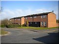
Houses off Goodman Way, Tanyard Farm estate
At the south end of Image
Image: © Richard Vince
Taken: 2 Apr 2016
0.21 miles
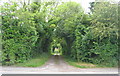
6
The edge of Tilehill Wood
Tilehill Wood is, according to the notice at the entrance, a "Nature reserve. Managed by: Coventry City Council Leisure Services and English Nature. Supported by: Countryside Commission. Forestry Commission".
The wood is one of several small pockets of woodland, originally on the Stoneleigh Estate, that were retained after over 2000 acres of estate land were purchased for city development by the City Council in the 1920s.
Image: © E Gammie
Taken: 19 Jun 2010
0.24 miles