IMAGES TAKEN NEAR TO
Robert Mounford Way, COVENTRY, CV4 9WY
Introduction
This page details the photographs taken nearby to Robert Mounford Way, CV4 9WY by members of the Geograph project.
The Geograph project started in 2005 with the aim of publishing, organising and preserving representative images for every square kilometre of Great Britain, Ireland and the Isle of Man.

There are currently over 7.5m images from over14,400 individuals and you can help contribute to the project by visiting https://www.geograph.org.uk
Image Map
Images are licensed for reuse under creativecommons.org/licenses/by-sa/2.0
Notes
- Clicking on the map will re-center to the selected point.
- The higher the marker number, the further away the image location is from the centre of the postcode.
Image Listing (18 Images Found)
Images are licensed for reuse under creativecommons.org/licenses/by-sa/2.0
Image
Details
Distance
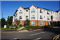
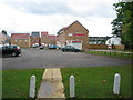
4

In place of Tile Hill College
A housing development on the old Tile Hill College site, Tile Hill Lane.
See also: http://www.geograph.org.uk/photo/48236 (2005)
and http://www.geograph.org.uk/photo/838733 (2008)
Image: © E Gammie
Taken: 23 Aug 2010
0.15 miles
5
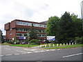
Tile Hill College
Or to use its full name, the Tile Hill Centre of the Coventry City College.
Image: © David Stowell
Taken: 29 Aug 2005
0.15 miles
6
Housing development, Tile Hill Lane
A mix of 1 to 4 bedroomed houses built on the former Tile Hill College site. Some look to be occupied, but the sales office and show homes are still there.
Image: © E Gammie
Taken: 23 Aug 2010
0.16 miles
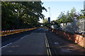
7
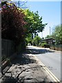
Wolfe Road
Wolfe Road runs south from Torrington Avenue to Charter Avenue via a narrow underbridge carrying the Coventry to Birmingham rail line.
Image: © E Gammie
Taken: 23 May 2010
0.16 miles
8

New houses, Tile Hill Lane
The somewhat grandiosely named 'Mowbray Manor' housing development built on the site of the former Tile Hill College. According to the sales blurb it is named after the 'Mowbray family who resided in the manor of Temple Balsall in the 13th century'. Tile Hill Lane, as the B4101, does connect with Temple Balsall but it seems a tenuous link. Perhaps I'm missing something.
Image: © E Gammie
Taken: 23 Aug 2010
0.16 miles
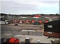
9
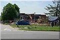
City College, Coventry being demolished
City College, or Tile Hill College as it was before being renamed, has now moved from this site to the Swanswell Learning Quarter in the centre of the city.
Image: © Keith Williams
Taken: 9 Jun 2008
0.19 miles
10
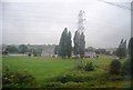
Pylon by the railway line in heavy rain
Image: © N Chadwick
Taken: 12 Jun 2011
0.19 miles