IMAGES TAKEN NEAR TO
Brockhurst Drive, COVENTRY, CV4 9UN
Introduction
This page details the photographs taken nearby to Brockhurst Drive, CV4 9UN by members of the Geograph project.
The Geograph project started in 2005 with the aim of publishing, organising and preserving representative images for every square kilometre of Great Britain, Ireland and the Isle of Man.

There are currently over 7.5m images from over14,400 individuals and you can help contribute to the project by visiting https://www.geograph.org.uk
Image Map
Images are licensed for reuse under creativecommons.org/licenses/by-sa/2.0
Notes
- Clicking on the map will re-center to the selected point.
- The higher the marker number, the further away the image location is from the centre of the postcode.
Image Listing (11 Images Found)
Images are licensed for reuse under creativecommons.org/licenses/by-sa/2.0
Image
Details
Distance
2
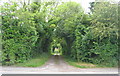
The edge of Tilehill Wood
Tilehill Wood is, according to the notice at the entrance, a "Nature reserve. Managed by: Coventry City Council Leisure Services and English Nature. Supported by: Countryside Commission. Forestry Commission".
The wood is one of several small pockets of woodland, originally on the Stoneleigh Estate, that were retained after over 2000 acres of estate land were purchased for city development by the City Council in the 1920s.
Image: © E Gammie
Taken: 19 Jun 2010
0.20 miles
3
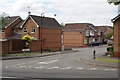
Hornbeam Drive, Tile Hill
Modern housing development off Tile Hill lane.
Image: © Stephen McKay
Taken: 14 Jul 2017
0.22 miles
4

Tile Hill, Hornbeam Drive
Modern suburban housing off Tile Hill Lane.
Image: © Mike Faherty
Taken: 19 Feb 2017
0.22 miles
5
Tile Hill, telephone exchange
On Tile Hill Lane.
Image: © Mike Faherty
Taken: 19 Feb 2017
0.23 miles
6
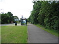
Bus stop on Banner Lane
But not just any bus stop. The orange glowing letters inside the stop tell you how long you've got to wait for the next bus.
Image: © E Gammie
Taken: 19 Jun 2010
0.23 miles
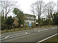
7
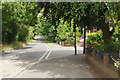
Tile Hill Lane
Showing the junction with Hathaway Road.
Image: © Stephen McKay
Taken: 14 Jul 2017
0.24 miles
8
Pig Wood
Pig Wood is one of several woodland areas around Tile Hill managed by Coventry City Council. According to Natural England the following tree species are present: Oak, Lime, Beech, Scots Pine, European Larch, Norway Spruce, Silver Birch, Ash, Sweet Chestnut, Rowan, Holly, Whitebeam, Aspen and Hornbeam. The name relates to the use of the wood for the grazing of swine.
Image: © Stephen McKay
Taken: 14 Jul 2017
0.24 miles
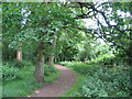
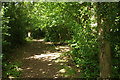
9
Tile Hill, woodland path
Through Pig Wood, a local nature reserve owned by Coventry City Council: oak, birch, holly and scattered conifers. http://www.coventry-walks.org.uk/booklets/woodland/tile-hill.html
Image: © Mike Faherty
Taken: 19 Feb 2017
0.24 miles
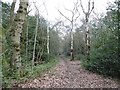
10

Tile Hill, woodland path
Through Plants Hill Wood, a local nature reserve owned by Coventry City Council: http://www.coventry-walks.org.uk/booklets/woodland/tile-hill.html
Image: © Mike Faherty
Taken: 19 Feb 2017
0.25 miles