IMAGES TAKEN NEAR TO
Falstaff Road, COVENTRY, CV4 9RW
Introduction
This page details the photographs taken nearby to Falstaff Road, CV4 9RW by members of the Geograph project.
The Geograph project started in 2005 with the aim of publishing, organising and preserving representative images for every square kilometre of Great Britain, Ireland and the Isle of Man.

There are currently over 7.5m images from over14,400 individuals and you can help contribute to the project by visiting https://www.geograph.org.uk
Image Map
Images are licensed for reuse under creativecommons.org/licenses/by-sa/2.0
Notes
- Clicking on the map will re-center to the selected point.
- The higher the marker number, the further away the image location is from the centre of the postcode.
Image Listing (17 Images Found)
Images are licensed for reuse under creativecommons.org/licenses/by-sa/2.0
Image
Details
Distance
1
Tile Hill, RC church
Our Lady of the Assumption, on Tile Hill Lane.
Image: © Mike Faherty
Taken: 19 Feb 2017
0.08 miles
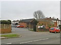
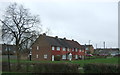
2
Bushberry Avenue
The actual street sign says Bushbery Avenue but streetmap uses two "R"'s. This is the junction with Tile Hill Rd. This area has large numbers of similar grey blocks of social housing, former Council flats.
Image: © Nigel Mykura
Taken: 6 Mar 2011
0.09 miles
3
Pig Wood
Access into Pig Wood from Hawthorn Lane.
Image: © Stephen McKay
Taken: 14 Jul 2017
0.10 miles
4
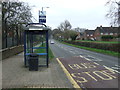
Bus stop and shelter on Tile Hill Lane
Looking east.
Image: © JThomas
Taken: 11 Mar 2017
0.10 miles
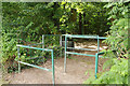
5
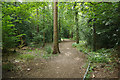
Pig Wood
Pig Wood is one of several woodland areas around Tile Hill managed by Coventry City Council. According to Natural England the following tree species are present: Oak, Lime, Beech, Scots Pine, European Larch, Norway Spruce, Silver Birch, Ash, Sweet Chestnut, Rowan, Holly, Whitebeam, Aspen and Hornbeam. The name relates to the use of the wood for the grazing of swine. Note the metal tap rail designed for people with visual impairment.
Image: © Stephen McKay
Taken: 14 Jul 2017
0.11 miles
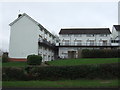
7
Tile Hill, Franklin Grove
Suburban housing off Gravel Hill.
Image: © Mike Faherty
Taken: 19 Feb 2017
0.14 miles
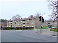
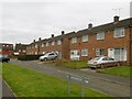
9

Roosevelt Drive, Tile Hill
Housing in Coventry's western suburbs, seen from the junction with Hawthorn Lane.
Image: © Stephen McKay
Taken: 14 Jul 2017
0.15 miles
10

Tile Hill Lane
The trees lining the road make it appear more rural than it is. Small areas of mature woodland were retained locally when the area was built on in the 1950s.
Image: © E Gammie
Taken: 23 Aug 2010
0.17 miles