IMAGES TAKEN NEAR TO
Hudson Vale, COVENTRY, CV4 9HT
Introduction
This page details the photographs taken nearby to Hudson Vale, CV4 9HT by members of the Geograph project.
The Geograph project started in 2005 with the aim of publishing, organising and preserving representative images for every square kilometre of Great Britain, Ireland and the Isle of Man.

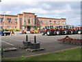
There are currently over 7.5m images from over14,400 individuals and you can help contribute to the project by visiting https://www.geograph.org.uk
Image Map
Images are licensed for reuse under creativecommons.org/licenses/by-sa/2.0
Notes
- Clicking on the map will re-center to the selected point.
- The higher the marker number, the further away the image location is from the centre of the postcode.
Image Listing (21 Images Found)
Images are licensed for reuse under creativecommons.org/licenses/by-sa/2.0
Image
Details
Distance
1
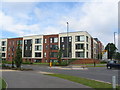
Banner Lane
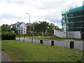
New apartments built on the former Massey Ferguson factory site.
Image: © E Gammie
Taken: 8 Jul 2012
0.09 miles
2
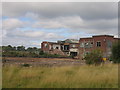
Demolition at Massey Ferguson
The once extensive Massey Ferguson site on Banner Lane in Coventry has been demolished from the back and is now reaching the main office buildings fronting on to Banner Lane itself.
Image: © David Stowell
Taken: 29 Aug 2005
0.09 miles
3
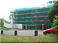
Banner Lane
Construction work at the southern end of the old Massey Ferguson factory site, with what appears to be the old factory gates retained.
Image: © E Gammie
Taken: 19 Jun 2010
0.09 miles
4
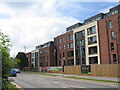
Banner Lane
New apartments facing Banner Lane, built on the former Massey Ferguson factory site.
Image: © E Gammie
Taken: 8 Jul 2012
0.09 miles
5
Massey Ferguson, Banner Lane, Coventry
One of the car parks at the front of the site is still used as a demonstration area for equipment carrying the Massey Ferguson brand, although it is no longer made on this site.
Image: © David Stowell
Taken: 29 Aug 2005
0.10 miles
6
Banner Lane
New apartments and construction work at the southern end of the former Massey Ferguson site.
Image: © E Gammie
Taken: 19 Jun 2010
0.10 miles
7

Massey Ferguson, Banner Lane, Coventry
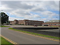
The Massey Ferguson flag still flies over one of the office blocks on this site which occupies almost a 3rd of the area of this square. Unfortunately the orange heaps just visible over the roof are all that is left of most of the factory as the demolition teams clear the site.
Image: © David Stowell
Taken: 29 Aug 2005
0.12 miles
8
Massey Ferguson, Banner Lane, Coventry
A general view of the southern part of the frontage on Banner Lane. Within a month this is likely to be history since the demolition people have already started work on the furthest office block.
Image: © David Stowell
Taken: 29 Aug 2005
0.14 miles
9
Tilehill Wood
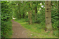
There is a significant amount of woodland in the Tile Hill area managed by Coventry City Council, including Tilehill Wood which covers 28.3 hectares. It is seen here close to Banner Lane. The wood was designated a Site of Special Scientific Interest in 1952 and is also a local nature reserve.
Image: © Stephen McKay
Taken: 14 Jul 2017
0.16 miles
10

Pond - Tilehill Wood
There is a series of ponds along the northern edge of Tilehill Wood, close to Woodlands School. This is the one nearest Banner Lane. Tilehill Wood is managed by Coventry City Council and is both a Site of Special Scientific Interest and a local nature reserve.
Image: © Stephen McKay
Taken: 14 Jul 2017
0.17 miles