IMAGES TAKEN NEAR TO
Torrington Avenue, COVENTRY, CV4 9HJ
Introduction
This page details the photographs taken nearby to Torrington Avenue, CV4 9HJ by members of the Geograph project.
The Geograph project started in 2005 with the aim of publishing, organising and preserving representative images for every square kilometre of Great Britain, Ireland and the Isle of Man.

There are currently over 7.5m images from over14,400 individuals and you can help contribute to the project by visiting https://www.geograph.org.uk
Image Map
Images are licensed for reuse under creativecommons.org/licenses/by-sa/2.0
Notes
- Clicking on the map will re-center to the selected point.
- The higher the marker number, the further away the image location is from the centre of the postcode.
Image Listing (7 Images Found)
Images are licensed for reuse under creativecommons.org/licenses/by-sa/2.0
Image
Details
Distance
2
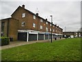
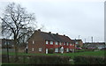
Tile Hill, shopping parade
Off Nickson Road; in the foreground, electrical servicing, barber, sunbeds, salon, charity shop, designer.
Image: © Mike Faherty
Taken: 19 Feb 2017
0.17 miles
5
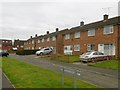
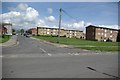
Tile Hill, Franklin Grove
Suburban housing off Gravel Hill.
Image: © Mike Faherty
Taken: 19 Feb 2017
0.20 miles
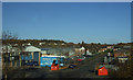
7
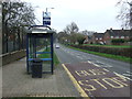
Bus stop and shelter on Tile Hill Lane
Looking east.
Image: © JThomas
Taken: 11 Mar 2017
0.23 miles