IMAGES TAKEN NEAR TO
Fir Tree Avenue, COVENTRY, CV4 9FR
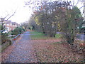
Introduction
This page details the photographs taken nearby to Fir Tree Avenue, CV4 9FR by members of the Geograph project.
The Geograph project started in 2005 with the aim of publishing, organising and preserving representative images for every square kilometre of Great Britain, Ireland and the Isle of Man.

There are currently over 7.5m images from over14,400 individuals and you can help contribute to the project by visiting https://www.geograph.org.uk
Image Map
Images are licensed for reuse under creativecommons.org/licenses/by-sa/2.0
Notes
- Clicking on the map will re-center to the selected point.
- The higher the marker number, the further away the image location is from the centre of the postcode.
Image Listing (16 Images Found)
Images are licensed for reuse under creativecommons.org/licenses/by-sa/2.0
Image
Details
Distance
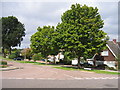
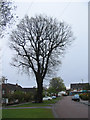
1

Oak, Broad Lane
On the verge in front of 1950s/60s detached houses on the north side of Broad Lane.
Image: © E Gammie
Taken: 12 Dec 2011
0.14 miles
2
Footway, Broad Lane
The pavement runs behind an old hedgerow on this part of Broad Lane. The houses on the left are detached dwellings, constructed in the 1950s/60s.
Image: © E Gammie
Taken: 16 Nov 2008
0.15 miles
3
Lime Tree Park
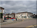
This is another area of pre-WWII housing expansion in Coventry. The view shows some of the local shops and housing at the junction of Elm Tree and Beech Tree Avenues near the middle of development.
Image: © David Stowell
Taken: 29 Aug 2005
0.15 miles
4
Shops, Lime Tree Park
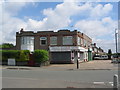
Castellated shops at the crossroads of Beech Tree Avenue and Elm Tree Avenue in the pre-WWII Lime Tree Park estate.
Image: © E Gammie
Taken: 8 Jul 2012
0.15 miles
5
Crossroads, Lime Tree Park
Strangely castellated buildings on the corner of Beech Tree Avenue and Elm Tree Avenue. Shops occupy other corners of this crossroads (Image and Image) and it is possible these were once shops. (Don Brooksbank confirms that in the 1970s a big hardware shop by the name of Tuck's used to occupy the whole of the ground floor of this building).
Image: © E Gammie
Taken: 8 Jul 2012
0.16 miles
6
Mount Nod, Coventry
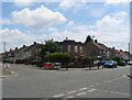
Looking west at the junction of Mount Nod Way with Nod Rise.
Image: © David Stowell
Taken: 29 Aug 2005
0.17 miles
7
Oak, Broad Lane
On the north side of Broad Lane by the junction with Nod Rise.
Image: © E Gammie
Taken: 12 Dec 2011
0.18 miles
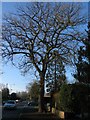
8
Oaks, Broad Lane
There are seven oaks, showing differing amounts of leaf fall, dotted along the north side of Broad Lane between the Larch Tree Avenue and Job's Lane junctions. An eighth stands on the south side at the Job's Lane corner.
Image: © E Gammie
Taken: 12 Dec 2011
0.20 miles
9
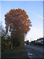
Oak, Broad Lane
An oak in the old hedgerow on Broad Lane. The pavement runs behind the hedgerow in front of post-WW2 houses. The houses on the right date mainly from the inter-war years.
Image: © E Gammie
Taken: 16 Nov 2008
0.20 miles
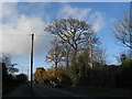
10
Tree, Mount Nod Way
Looking towards Nod Rise and its two shops.
Image: © E Gammie
Taken: 29 Apr 2012
0.21 miles