IMAGES TAKEN NEAR TO
Jobs Lane, COVENTRY, CV4 9EB
Introduction
This page details the photographs taken nearby to Jobs Lane, CV4 9EB by members of the Geograph project.
The Geograph project started in 2005 with the aim of publishing, organising and preserving representative images for every square kilometre of Great Britain, Ireland and the Isle of Man.

There are currently over 7.5m images from over14,400 individuals and you can help contribute to the project by visiting https://www.geograph.org.uk
Image Map
Images are licensed for reuse under creativecommons.org/licenses/by-sa/2.0
Notes
- Clicking on the map will re-center to the selected point.
- The higher the marker number, the further away the image location is from the centre of the postcode.
Image Listing (48 Images Found)
Images are licensed for reuse under creativecommons.org/licenses/by-sa/2.0
Image
Details
Distance
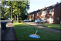

5

Bus in Jardine Crescent turning circle
Another long standing Coventry turning circle in which buses ceased to terminate in February 2012 (see also Image), the facility on Jardine Crescent was referred to on bus destination displays as "Tile Hill North".
Image: © Richard Vince
Taken: 4 Oct 2011
0.11 miles
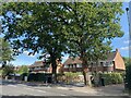
6
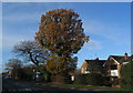
Broad Lane oak
The oak tree stands at the junction of Jobs Lane with Broad Lane, two of the roads pre-dating the suburban expansion of Coventry. The houses in the background date from about the 1960s.
Image: © E Gammie
Taken: 13 Nov 2011
0.11 miles
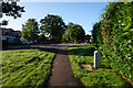
7

Bus stop at eastern end of Jardine Crescent, Tile Hill
Behind the bus stop on the corner of Job's Lane is a plot which has been vacant for several years. Don Brooksbank informs us that it was the site of a pub called the "New Star" in the 1970s. It was later renamed "The Woodsman" before being subsequently closed. While derelict, it was damaged by arson in 2001 and then finally demolished four years later.
Image: © John Brightley
Taken: 31 Aug 2010
0.12 miles
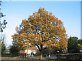
8
Oaks and bus shelter, Broad Lane
Unlike nearby oaks, the foremost one has lost little of its leaf cover. To the right are 1950s/60s detached houses on the north side of Broad Lane.
Image: © E Gammie
Taken: 13 Dec 2011
0.12 miles
9

Job's Lane, southwards
Job's Lane is shown on old Ordnance Survey maps as one of three lanes running N-S between Broad Lane and Tile Hill Lane.
Image: © E Gammie
Taken: 23 Aug 2010
0.13 miles
10
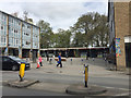
Shopping court, Jardine Shopping Centre, Tile Hill North, western Coventry
Behind the camera is Limbrick Wood, known once as North Waste. Behind the shops and flats are mature trees, Jardine Wood, creating the appearance of a woodland setting – unusual and calming, however it has been brought about.
Image: © Robin Stott
Taken: 11 Apr 2017
0.13 miles