IMAGES TAKEN NEAR TO
Tile Hill Lane, COVENTRY, CV4 9DW
Introduction
This page details the photographs taken nearby to Tile Hill Lane, CV4 9DW by members of the Geograph project.
The Geograph project started in 2005 with the aim of publishing, organising and preserving representative images for every square kilometre of Great Britain, Ireland and the Isle of Man.

There are currently over 7.5m images from over14,400 individuals and you can help contribute to the project by visiting https://www.geograph.org.uk
Image Map
Images are licensed for reuse under creativecommons.org/licenses/by-sa/2.0
Notes
- Clicking on the map will re-center to the selected point.
- The higher the marker number, the further away the image location is from the centre of the postcode.
Image Listing (57 Images Found)
Images are licensed for reuse under creativecommons.org/licenses/by-sa/2.0
Image
Details
Distance

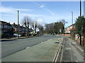
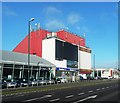
3
Tile Hill Lane
The 1930s houses are dwarfed by the casino on the corner of Tile Hill Lane (B4101) and Fletchamstead Highway (A45). It was originally opened as the Standard Cinema in 1938, the last venture of Coventry's first cinema owner, Mr Augustus Pell. Later named the Godiva, it continued as an independent cinema until the 1970s.
Tile Hill Lane is one of the main roads into the city centre from the western side of the city.
2012 update: The building has since been painted red: http://www.geograph.org.uk/photo/3270570
Image: © E Gammie
Taken: 2 Dec 2008
0.05 miles
4
Barclays Bank, Fletchamstead Highway
This branch at the junction of Tile Hill Lane and Fletchamstead Highway (A45) closed on 17 April 2020.
Image: © E Gammie
Taken: 25 Dec 2012
0.06 miles
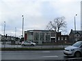
6
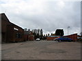
The Highway Club, Fletchamstead Highway
The Highway Club was formerly the sports and social club for Coventry Gauge and Tool which had a large factory nearby. Between the buildings and the poplar trees is the club's sports ground. The building on the left is part of what was the Matrix Hall.
Image: © E Gammie
Taken: 14 Oct 2017
0.07 miles
7

Domino's Pizza on Fletchamstead Highway, Whoberley
Attached to Winners Chapel
Image: © David Howard
Taken: 21 May 2023
0.08 miles
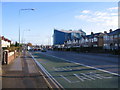
8
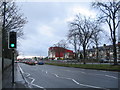
Fletchamstead Highway
Looking south from the pedestrian crossing on the A45 and the sun is breaking through a little after a dismal rainy morning.
The traffic is queueing at the junction with Tile Hill Lane, dominated by the large red casino building which was formerly a cinema. Beyond it are a variety of industrial units and car showrooms.
The casino was previously blue: http://www.geograph.org.uk/photo/1067314 (2008)
Image: © E Gammie
Taken: 25 Dec 2012
0.08 miles
9

Co-op Corner of Tile Hill Lane and Eastcotes
Co-op Store
Image: © David Walton
Taken: 6 Feb 2002
0.08 miles
10

A45, Fletchamstead Highway
Commercial/industrial units line this part of the highway and have done since it was built in the 1930s, although two buildings here have been demolished and rebuilt as car showrooms. From the left: car showroom, warehouse, hire company, entrance to Highway sports and social club, car showroom, casino and pizza outlet.
Image: © E Gammie
Taken: 30 Nov 2008
0.08 miles