IMAGES TAKEN NEAR TO
Lawley Close, COVENTRY, CV4 9BZ
Introduction
This page details the photographs taken nearby to Lawley Close, CV4 9BZ by members of the Geograph project.
The Geograph project started in 2005 with the aim of publishing, organising and preserving representative images for every square kilometre of Great Britain, Ireland and the Isle of Man.

There are currently over 7.5m images from over14,400 individuals and you can help contribute to the project by visiting https://www.geograph.org.uk
Image Map
Images are licensed for reuse under creativecommons.org/licenses/by-sa/2.0
Notes
- Clicking on the map will re-center to the selected point.
- The higher the marker number, the further away the image location is from the centre of the postcode.
Image Listing (25 Images Found)
Images are licensed for reuse under creativecommons.org/licenses/by-sa/2.0
Image
Details
Distance

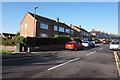
2

Job's Lane Lime Tree Park
View south along this residential suburban street in Tile Hill. Baxter Close is off on the left in the middle distance and Jardine Crescent is the road in the right foreground.
Image: © Nigel Mykura
Taken: 6 Mar 2011
0.10 miles
3

Job's Lane, southwards
Job's Lane is shown on old Ordnance Survey maps as one of three lanes running N-S between Broad Lane and Tile Hill Lane.
Image: © E Gammie
Taken: 23 Aug 2010
0.12 miles
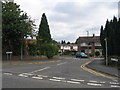
5

Bus stop at eastern end of Jardine Crescent, Tile Hill
Behind the bus stop on the corner of Job's Lane is a plot which has been vacant for several years. Don Brooksbank informs us that it was the site of a pub called the "New Star" in the 1970s. It was later renamed "The Woodsman" before being subsequently closed. While derelict, it was damaged by arson in 2001 and then finally demolished four years later.
Image: © John Brightley
Taken: 31 Aug 2010
0.13 miles

7
Gaza Close, Tile Hill, Coventry
A typical infill development in the largely pre-WWI housing area occupying much of this square. Gaza Close is situated off Job's Lane.
Image: © David Stowell
Taken: 29 Aug 2005
0.14 miles
8

Bus in Jardine Crescent turning circle
Another long standing Coventry turning circle in which buses ceased to terminate in February 2012 (see also Image), the facility on Jardine Crescent was referred to on bus destination displays as "Tile Hill North".
Image: © Richard Vince
Taken: 4 Oct 2011
0.14 miles
9

Job's Lane, northwards
Looking up hill from its junction with Tile Hill Lane.
Image: © E Gammie
Taken: 23 Aug 2010
0.15 miles
10
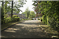
Limbrick Avenue
A very leafy, desirable suburb of Coventry.
Image: © Malcolm Neal
Taken: 31 May 2018
0.17 miles