IMAGES TAKEN NEAR TO
Torrington Avenue, COVENTRY, CV4 9AR
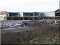
Introduction
This page details the photographs taken nearby to Torrington Avenue, CV4 9AR by members of the Geograph project.
The Geograph project started in 2005 with the aim of publishing, organising and preserving representative images for every square kilometre of Great Britain, Ireland and the Isle of Man.

There are currently over 7.5m images from over14,400 individuals and you can help contribute to the project by visiting https://www.geograph.org.uk
Image Map
Images are licensed for reuse under creativecommons.org/licenses/by-sa/2.0
Notes
- Clicking on the map will re-center to the selected point.
- The higher the marker number, the further away the image location is from the centre of the postcode.
Image Listing (36 Images Found)
Images are licensed for reuse under creativecommons.org/licenses/by-sa/2.0
Image
Details
Distance
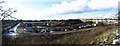
1
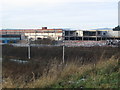
Wholesale warehouse
A wholesale warehouse on Torrington Avenue which was built on the site of the former Torrington factory. Seen across the Coventry-Birmingham railway line.
In 2009: Image
Image: © E Gammie
Taken: 20 Mar 2014
0.05 miles
2
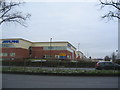
Business park, Fletchamstead Highway
A small business park built alongside the A45 on the site of the former Coventry Gauge & Tool factory which occupied the site from 1936 to the 1990s
Image: © E Gammie
Taken: 17 Jan 2016
0.07 miles
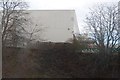
3
Torrington Avenue corner
The former Torrington Co. factory has been demolished and 1920s/30s houses on Torrington Avenue are now visible on the right, with the Coventry to Birmingham rail line visible on the left. In general the area between Torrington Avenue and the railway line is occupied by a mix of commercial and factory premises.
Image: © E Gammie
Taken: 21 Feb 2010
0.08 miles
4

Big cat, Fletchamstead Highway
The beautifully styled leaping cat mascot of Jaguar cars, displayed outside the dealership on the A45. The mascot is based on a 1937 design by F Gordon Crosby and has been associated with Jaguar since that time.
Image: © E Gammie
Taken: 23 Dec 2009
0.08 miles
5
Factory demolition, Fletchamstead Highway
Demolition of the former Torrington Co. factory, built in the 1930s on the corner of Torrington Avenue and Fletchamstead Highway (A45). The land between Torrington Avenue to the north and the rail line to the south is predominantly industrial or commercial use.
Image: © E Gammie
Taken: 23 Dec 2009
0.09 miles
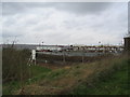
7
Factory demolition, Fletchamstead Highway
Demolition of the former Torrington Co. factory built on the corner of Torrington Avenue and Fletchamstead Highway (A45) in the 1930s. In the foreground, the gantries of the Coventry to Birmingham railway. The land between Torrington Avenue to the north and the rail line to the south is predominantly industrial or commercial use.
Image: © E Gammie
Taken: 23 Dec 2009
0.09 miles
8
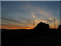
Sunset over Earlplace business park
Just before sunset on the longest day of the year. The cloud effects are mostly decaying con-trails from planes heading for/leaving Birmingham airport, Elmdon. Time 21:31. Sunset 21:34.
Image: © E Gammie
Taken: 21 Jun 2010
0.10 miles
9
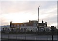
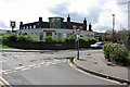
The Fletch, Fletchamstead Highway
The sun setting behind the boarded up 1930s Art Deco style Fletch public house. The site has since been converted to a second hand car dealership ( Image] ), retaining the renovated building.
Compare with May 2008: http://www.geograph.org.uk/photo/787126
Image: © E Gammie
Taken: 30 Nov 2008
0.12 miles