IMAGES TAKEN NEAR TO
Goldcrest Walk, COVENTRY, CV4 8NF
Introduction
This page details the photographs taken nearby to Goldcrest Walk, CV4 8NF by members of the Geograph project.
The Geograph project started in 2005 with the aim of publishing, organising and preserving representative images for every square kilometre of Great Britain, Ireland and the Isle of Man.

There are currently over 7.5m images from over14,400 individuals and you can help contribute to the project by visiting https://www.geograph.org.uk
Image Map
Images are licensed for reuse under creativecommons.org/licenses/by-sa/2.0
Notes
- Clicking on the map will re-center to the selected point.
- The higher the marker number, the further away the image location is from the centre of the postcode.
Image Listing (54 Images Found)
Images are licensed for reuse under creativecommons.org/licenses/by-sa/2.0
Image
Details
Distance
1
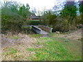
Canley, footbridge
Over Canley Brook, from Prior Deram Recreation Ground.
Image: © Mike Faherty
Taken: 7 Feb 2015
0.02 miles
2
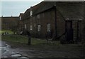
Moat House cottages
Nos. 1 and 2 Moat House cottages, no. 2 being the nearest, according to the small sign in the foreground. No. 1 was the birthplace in 1815 of Sir Henry Parkes, later to become Prime Minister of New South Wales. In the background are the rear of houses on Sir Henry Parkes Road.
In 2010: http://www.geograph.org.uk/photo/2110337
Timber frame and brick. Grade II listed.
Image: © E Gammie
Taken: 26 Dec 1978
0.06 miles
3
Moat House cottages
At the end of Moat House Lane and facing woodland, a timber frame and brick building, dating from the 16th century, divided into two cottages, No. 1 and No. 2. No.1 was the birthplace, on 27 May 1815, of Sir Henry Parkes who went on to become Prime Minister of New South Wales, Australia.
Grade II listed building. LBS no. 218537
Compare with 1978: http://www.geograph.org.uk/photo/2111087
Image: © E Gammie
Taken: 13 Oct 2010
0.06 miles
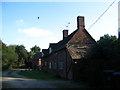
4
Canley, Moat House Lane
Suburban road and housing, off Charter Avenue.
Image: © Mike Faherty
Taken: 7 Feb 2015
0.07 miles
5
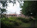
Construction work, Prior Deram park
New residences under construction on the former recreation ground, a small area of which has been retained as a playground. Viewed from the footpath alongside the Canley Brook.
Image: © E Gammie
Taken: 28 Aug 2020
0.08 miles
6
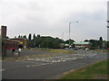
Fletchamstead Highway Roundabout
At the junction with Sir Henry Parkes Road, with the local fire and police stations.
Image: © David Stowell
Taken: 23 Jul 2005
0.11 miles
7
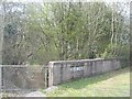
Bridge over Canley Brook, A45
The western parapet of one of the two bridges carrying Fletchamstead Highway over the Canley Brook, stencilled with '249 70Q'. The direction of stream flow is north-eastward.
Image: © E Gammie
Taken: 9 Apr 2015
0.12 miles
8
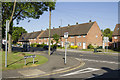
Sir Henry Parkes Road
Just off the A45 Sir Henry Parkes Road leads directly to the campus of Warwick University. The side road from where the picture was taken is Centenary Road and is a residential road.
Image: © Malcolm Neal
Taken: 26 May 2017
0.12 miles
9
BISF 'Type A' houses, Freeburn Causeway, Canley
The Second World War led to large-scale destruction in Coventry, but also to large-scale migration of workers to the city and its engineering industries that were essential to the war effort. To address the housing shortage, the city council experimented with designing prefabricated metal-framed houses that could be built quickly using components mass-produced in the same factories.
These houses were never put into production, however, as central government offered Coventry two thousand prefabricated houses instead. These were made by the British Iron & Steel Federation (BISF) and were called 'Type A' houses. They too used a prefabricated steel-framed system, to which panels of corrugated steel were attached, forming the outer walls of the upper storey. The design was by the architect Frederick Gibberd and the engineer Donovan Lee.
Owing to labour shortages, Coventry never built most of these houses, but over two hundred were erected in Canley in the late 1940s and most are still in use. Often the steel walls have been covered with insulating cladding, but the two in the foreground of this photo still display the panels of corrugated steel, although the original windows and doors have been replaced.
For more information see Coventry: The making of a modern city, 1939-73, by Jeremy Gould and Caroline Gould, pp83-84, available at the Historic England site https://historicengland.org.uk/images-books/publications/coventry-making-of-modern-city-1939-73/ . Connoisseurs of BISF houses will find many examples on Geograph: see for example Image], Image] and Image
Image: © A J Paxton
Taken: 26 May 2023
0.12 miles
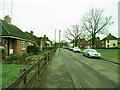
10
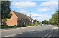
Sir Henry Parkes Road, Canley
Much of this locality has housing of this style - originally built as council housing in the 1950s. A pedestrian crossing has been added and the bus-stop altered since 2005: Image]
Image: © E Gammie
Taken: 12 Sep 2020
0.12 miles