IMAGES TAKEN NEAR TO
Penruddock Drive, COVENTRY, CV4 8LR
Introduction
This page details the photographs taken nearby to Penruddock Drive, CV4 8LR by members of the Geograph project.
The Geograph project started in 2005 with the aim of publishing, organising and preserving representative images for every square kilometre of Great Britain, Ireland and the Isle of Man.

There are currently over 7.5m images from over14,400 individuals and you can help contribute to the project by visiting https://www.geograph.org.uk
Image Map
Images are licensed for reuse under creativecommons.org/licenses/by-sa/2.0
Notes
- Clicking on the map will re-center to the selected point.
- The higher the marker number, the further away the image location is from the centre of the postcode.
Image Listing (49 Images Found)
Images are licensed for reuse under creativecommons.org/licenses/by-sa/2.0
Image
Details
Distance
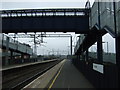
1
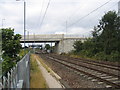
Tile Hill Station and new bridge
Looking west along the WCML between Coventry and Birmingham with Tile Hill Station visible under the bridge. This bridge has only opened this year and replaces a level crossing (see Image ) just beyond, one of the 3 between Coventry and Birmingham eliminated as part of the line upgrade.
Image: © David Stowell
Taken: 29 Aug 2005
0.00 miles
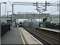
4
Tile Hill Station
On the Coventry to Birmingham section of the West Coast line, the station formerly known as Allesley Gate. Taken from the road overbridge, which has replaced the level crossing.
Image: © E Gammie
Taken: 23 May 2010
0.02 miles
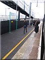
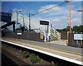
5
Platform 2, Tile Hill Railway Station
Looking west.
Image: © JThomas
Taken: 11 Mar 2017
0.02 miles
6
Tile Hill Station
On the Coventry to Birmingham Line.
Image: © Ian Rob
Taken: 6 Aug 2018
0.02 miles
7

Tile Hill Station
A station on the Coventry-Birmingham section of the West Coast Main Line. To the left, fencing and scaffolding around work still in progress on construction of residential apartments on the former Midland Sports Centre for the Disabled site.
Image: © E Gammie
Taken: 13 Nov 2011
0.02 miles
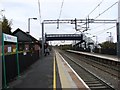
8
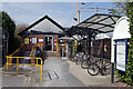
Tile Hill Station
Tile Hill serves a suburban area on the western outskirts of Coventry and is an intermediate station between Coventry and Birmingham. The small building on the south (down) side of the line houses a ticket office but this was closed in this view. The board on the right gives onward travel information including a local map and details of bus and taxi services.
Image: © Stephen McKay
Taken: 14 Apr 2021
0.03 miles
9
Platform 2, Tile Hill Railway Station
Looking east.
Image: © JThomas
Taken: 11 Mar 2017
0.03 miles
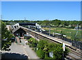
10

Tile Hill railway station, West Midlands
Opened in 1848 by the London & Birmingham Railway on the section between Coventry and Birmingham, this station was originally called "Allesley Gate" and then "Allesley Lane" until 1864.
View east towards Canley and Coventry.
The traditional layout until a few years ago was a level crossing where the road bridge now is, and the Coventry-bound platform was on the far side of that crossing.
Image: © Nigel Thompson
Taken: 19 Nov 2011
0.03 miles