IMAGES TAKEN NEAR TO
Skylark Street, COVENTRY, CV4 8JG
Introduction
This page details the photographs taken nearby to Skylark Street, CV4 8JG by members of the Geograph project.
The Geograph project started in 2005 with the aim of publishing, organising and preserving representative images for every square kilometre of Great Britain, Ireland and the Isle of Man.

There are currently over 7.5m images from over14,400 individuals and you can help contribute to the project by visiting https://www.geograph.org.uk
Image Map
Images are licensed for reuse under creativecommons.org/licenses/by-sa/2.0
Notes
- Clicking on the map will re-center to the selected point.
- The higher the marker number, the further away the image location is from the centre of the postcode.
Image Listing (29 Images Found)
Images are licensed for reuse under creativecommons.org/licenses/by-sa/2.0
Image
Details
Distance
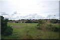
1
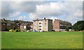
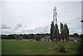
Flats and houses, Donegal Close, Canley, Coventry
The view is from the open space between the residential area and the railway, traversed by the meandering Canley Brook.
Image: © Robin Stott
Taken: 3 Aug 2013
0.04 miles
2
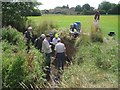
Fathoming the geology of the Canley Brook, Canley, Coventry
Members of the Warwickshire Geological Conservation Group http://www.wgcg.co.uk enjoy getting in the water to study the strata exposed by the meandering brook; Brian Ellis, chairman, putting the questions, right. This was one of several south Coventry sites visited on a sunshine-and-showers August day.
Image: © Robin Stott
Taken: 3 Aug 2013
0.04 miles
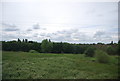
3
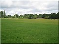
Open space to the south of the Canley Brook, Canley, Coventry
This wide green space keeps the railway (on embankment) and the brook at a distance from houses.
Image: © Robin Stott
Taken: 3 Aug 2013
0.05 miles
4
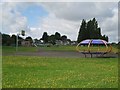
Teen zone, open space by Canley Brook, Canley, Coventry
It's well understood by local authorities and the play equipment industry that teenagers and young adults appreciate their own space, mainly to meet, separate from play areas for children. Here there's a shelter with seats and a basketball hoop.
Image: © Robin Stott
Taken: 3 Aug 2013
0.06 miles
7
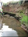
Strata exposed in the bank of the Canley Brook, Canley, Coventry
Below the top layer of glacial deposit are layers of sandstone, Mercia Mudstone and pebbles that speak of flash floods and seasonal lakes in a desert environment.
Image: © Robin Stott
Taken: 3 Aug 2013
0.08 miles
8
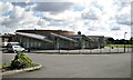
Charter Primary School, Canley Children?s Centre, Mitchell Avenue, Canley, Coventry
A Coventry City Council school. The sign at the gate carries the 'Sure Start' and NHS Coventry logos.
Image: © Robin Stott
Taken: 3 Aug 2013
0.10 miles
9
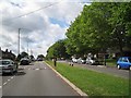
South on Mitchell Avenue (north of Charter Avenue), Canley, Coventry
It looks at first sight like dual carriageway but it isn't. The road on the right gives access to properties only. Mitchell Avenue looks like a road that never went as far as it was meant to. Templar Avenue north of the railway is a similar stub. Connected, they might have formed a north-south route west of the city centre. Pure speculation of course.
Image: © Robin Stott
Taken: 3 Aug 2013
0.14 miles