IMAGES TAKEN NEAR TO
Edwin Rogers Walk, COVENTRY, CV4 8HG
Introduction
This page details the photographs taken nearby to Edwin Rogers Walk, CV4 8HG by members of the Geograph project.
The Geograph project started in 2005 with the aim of publishing, organising and preserving representative images for every square kilometre of Great Britain, Ireland and the Isle of Man.

There are currently over 7.5m images from over14,400 individuals and you can help contribute to the project by visiting https://www.geograph.org.uk
Image Map
Images are licensed for reuse under creativecommons.org/licenses/by-sa/2.0
Notes
- Clicking on the map will re-center to the selected point.
- The higher the marker number, the further away the image location is from the centre of the postcode.
Image Listing (11 Images Found)
Images are licensed for reuse under creativecommons.org/licenses/by-sa/2.0
Image
Details
Distance
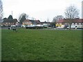
1
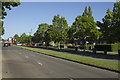
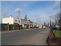
Charter Avenue
A wide residential road with ample grassy verges is Charter Avenue. The road leads to an industrial estate and Warwick University.
Image: © Malcolm Neal
Taken: 26 May 2017
0.14 miles
2
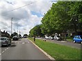
South on Mitchell Avenue (north of Charter Avenue), Canley, Coventry
It looks at first sight like dual carriageway but it isn't. The road on the right gives access to properties only. Mitchell Avenue looks like a road that never went as far as it was meant to. Templar Avenue north of the railway is a similar stub. Connected, they might have formed a north-south route west of the city centre. Pure speculation of course.
Image: © Robin Stott
Taken: 3 Aug 2013
0.17 miles
3
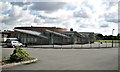
Charter Primary School, Canley Children?s Centre, Mitchell Avenue, Canley, Coventry
A Coventry City Council school. The sign at the gate carries the 'Sure Start' and NHS Coventry logos.
Image: © Robin Stott
Taken: 3 Aug 2013
0.18 miles
4
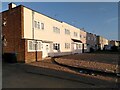
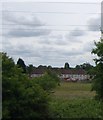
Coventry Corporation council housing, Sheriff Avenue, Canley
These houses were built in 1940-41 to designs by the City Architect's Department under the newly appointed Donald Gibson. They are contemporary, therefore, with the large air raids on Coventry and Gibson's first plans for a modern shopping precinct to be built as part of the reconstruction of the destroyed city centre.
These houses are in a modernist style, too, with flat roofs and plain brick walls, although most have since been rendered and the windows replaced. They were among the first council houses to be built in Canley, which was to become a large housing estate on the western edge of the city. Other houses built by the city in this area at the same time had more conventional pitched-roof designs. See Coventry: The making of a modern city by Jeremy Gould & Caroline Gould, p82, at the Historic England site https://historicengland.org.uk/images-books/publications/coventry-making-of-modern-city-1939-73/ . Similar houses on the opposite side of Sheriff Avenue can be seen at Image
Image: © A J Paxton
Taken: 26 May 2023
0.19 miles
5
Sheriff Avenue, Canley
Houses on Sheriff Avenue, built 1940-41 to a design by city architect Donald Gibson.
Image: © E Gammie
Taken: 26 Feb 2016
0.19 miles
7
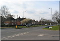
Charter Avenue, Canley
At the junction with Sheriff Avenue. The semis alongside the dual carriageway were originally council housing.
Image: © E Gammie
Taken: 26 Feb 2016
0.20 miles
9
Prior Deram Walk
Shops and Canley Cummunity Centre.
Image: © E Gammie
Taken: 2 Mar 2021
0.23 miles
10
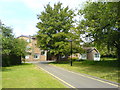
Bericote Hall
Student residence on the Westwood Campus of the University of Warwick. Was formerly part of Coventry College of Education before incorporation into the University in 1978.
Image: © Keith Williamson
Taken: 4 Jun 2009
0.24 miles