IMAGES TAKEN NEAR TO
Whitefield Close, COVENTRY, CV4 8GY
Introduction
This page details the photographs taken nearby to Whitefield Close, CV4 8GY by members of the Geograph project.
The Geograph project started in 2005 with the aim of publishing, organising and preserving representative images for every square kilometre of Great Britain, Ireland and the Isle of Man.

There are currently over 7.5m images from over14,400 individuals and you can help contribute to the project by visiting https://www.geograph.org.uk
Image Map
Images are licensed for reuse under creativecommons.org/licenses/by-sa/2.0
Notes
- Clicking on the map will re-center to the selected point.
- The higher the marker number, the further away the image location is from the centre of the postcode.
Image Listing (11 Images Found)
Images are licensed for reuse under creativecommons.org/licenses/by-sa/2.0
Image
Details
Distance
1
Westwood Heath Road
Westward Heath came within the Coventry boundary with the 1928 boundary extensions. However it remained largely rural until the last quarter of the 20th century, when housing and a business park were constructed.
Image: © E Gammie
Taken: 13 Nov 2011
0.12 miles
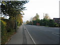
2
Westwood Heath Road
On the very south west edge of Coventry close to the Westwood Business Park all the houses are to the north (right) of the road with fields to the south (left).
Image: © Malcolm Neal
Taken: 1 Jun 2018
0.14 miles
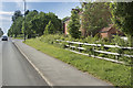
3
Westwood Heath Road
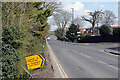
Westwood Heath Road runs along the boundary between Coventry And Warwickshire. At this point, there is housing to the left with open vistas over Warwickshire farmland. Once a quiet backwater, the road has become a bit of a race track in recent years hence the solar-power assisted 30mph warning signs, one of which is visible to the left of the oak which stands at the lane entrance to Lodge Farm.
Image: © E Gammie
Taken: 13 Nov 2011
0.15 miles
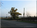
4
Cromwell Lane, Tile Hill
This location is just inside the Coventry city boundary. Westwood Heath Road leads off to the right.
Image: © Stephen McKay
Taken: 14 Apr 2021
0.16 miles
5
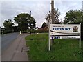
Welcome to the City of Coventry, Tile Hill
This sign, by the junction of Cromwell Lane and Westwood Heath Road, marks the boundary between Burton Green, a ribbon development suburb in Warwickshire, and Tile Hill in Coventry.
Image: © A J Paxton
Taken: 7 Oct 2023
0.17 miles
6
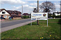
Entering Coventry
The large sign marks the boundary of the City of Coventry on Cromwell Lane. The strapline 'City of Peace and Reconciliation' refers back to the night in November 1940 when the cathedral and much of the city centre were destroyed by enemy action. Following that the Cathedral's provost urged people not to seek revenge, but to forgive. After the Second World War reconciliation links were set up with Dresden, Germany which had also suffered a devastating firebomb raid, and later Coventry was twinned with Hiroshima, Stalingrad, Lidice and Caen. In 2000 a Centre for the Study of Forgiveness and Reconciliation was established at Coventry University. At the bottom of the sign is a reminder that Coventry has been designated UK City of Culture for 2021.
Image: © Stephen McKay
Taken: 14 Apr 2021
0.19 miles
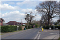
7
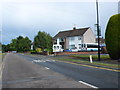
Houses on Charter Avenue
This pair of semi-detached houses is on the south side of Charter Avenue close to the junction with Dalmeny Road.
Image: © Nigel Mykura
Taken: 11 Jun 2011
0.19 miles
8
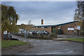
Quantum Business
At the side of Charter Avenue is the business called Quantum. It produces car seating according to their web site.
Image: © Malcolm Neal
Taken: 7 Nov 2018
0.20 miles
9
Cromwell Lane, Tile Hill
A sign points into Charter Avenue to the Xcel leisure centre where covid-19 tests for anyone displaying no symptoms are available. The facility was set up in February 2021.
Image: © Stephen McKay
Taken: 14 Apr 2021
0.23 miles
10
Westwood Farm, Cromwell Lane, Tile Hill
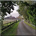
The western edge of Coventry is marked here by Cromwell Lane: on the eastern side, ribbon development housing, to the west, seen here, there is farmland between and behind the houses. The farm track is not a public right of way.
Image: © A J Paxton
Taken: 7 Oct 2023
0.23 miles