IMAGES TAKEN NEAR TO
Glebe Close, COVENTRY, CV4 8DJ
Introduction
This page details the photographs taken nearby to Glebe Close, CV4 8DJ by members of the Geograph project.
The Geograph project started in 2005 with the aim of publishing, organising and preserving representative images for every square kilometre of Great Britain, Ireland and the Isle of Man.

There are currently over 7.5m images from over14,400 individuals and you can help contribute to the project by visiting https://www.geograph.org.uk
Image Map
Images are licensed for reuse under creativecommons.org/licenses/by-sa/2.0
Notes
- Clicking on the map will re-center to the selected point.
- The higher the marker number, the further away the image location is from the centre of the postcode.
Image Listing (31 Images Found)
Images are licensed for reuse under creativecommons.org/licenses/by-sa/2.0
Image
Details
Distance
1
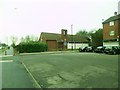
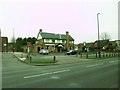
Canley, St. Stephen's
Anglican church next to a shopping parade on Charter Avenue. http://coventry.fsd.org.uk/kb5/coventry/fsd/organisation.page?record=FyvP0WySFbo
Image: © Mike Faherty
Taken: 7 Feb 2015
0.06 miles
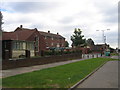
2
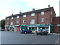
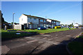
Shops on Charter Avenue
This small row of shops is built into a small block of flats. It is next door to the Sovereign Pub and opposite Ten Shilling Wood. Although there are two empty closed shops in the row, three of the other shops have been combined and taken over by a convenience store, S&S Charter stores which sells a wide range of goods and hires videos. There is also a post Office that is still surviving.
Image: © Nigel Mykura
Taken: 11 Jun 2011
0.08 miles
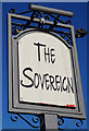
3
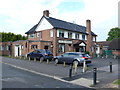
The Sovereign Public House
Probably built in the 1960's this pub is on the north side of Charter Avenue between a church and a row of shops.
Image: © Nigel Mykura
Taken: 11 Jun 2011
0.09 miles
5
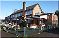
Canley, The Sovereign
Suburban pub on Charter Avenue.
Image: © Mike Faherty
Taken: 7 Feb 2015
0.09 miles
8
Two churches, some shops and a pub, Charter Avenue, Canley
From left to right, St Peter's the Martyr Church, the local shopping precinct, The Half Sovereign pub and immediately beyond, The Canley Evangelical Church.
Image: © David Stowell
Taken: 29 Aug 2005
0.12 miles
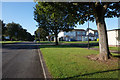
10
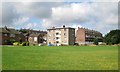
Flats and houses, Donegal Close, Canley, Coventry
The view is from the open space between the residential area and the railway, traversed by the meandering Canley Brook.
Image: © Robin Stott
Taken: 3 Aug 2013
0.12 miles