IMAGES TAKEN NEAR TO
Kele Road, COVENTRY, CV4 8DH
Introduction
This page details the photographs taken nearby to Kele Road, CV4 8DH by members of the Geograph project.
The Geograph project started in 2005 with the aim of publishing, organising and preserving representative images for every square kilometre of Great Britain, Ireland and the Isle of Man.

There are currently over 7.5m images from over14,400 individuals and you can help contribute to the project by visiting https://www.geograph.org.uk
Image Map
Images are licensed for reuse under creativecommons.org/licenses/by-sa/2.0
Notes
- Clicking on the map will re-center to the selected point.
- The higher the marker number, the further away the image location is from the centre of the postcode.
Image Listing (32 Images Found)
Images are licensed for reuse under creativecommons.org/licenses/by-sa/2.0
Image
Details
Distance
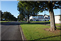
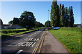
3
Whitchurch Way, Canley
At the junction with Wolfe Road.
Image: © John Brightley
Taken: 31 Aug 2010
0.08 miles
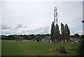
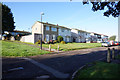
9
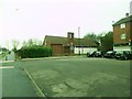
Canley, St. Stephen's
Anglican church next to a shopping parade on Charter Avenue. http://coventry.fsd.org.uk/kb5/coventry/fsd/organisation.page?record=FyvP0WySFbo
Image: © Mike Faherty
Taken: 7 Feb 2015
0.12 miles
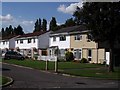
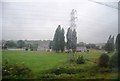
10
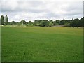
Open space to the south of the Canley Brook, Canley, Coventry
This wide green space keeps the railway (on embankment) and the brook at a distance from houses.
Image: © Robin Stott
Taken: 3 Aug 2013
0.13 miles